Begin Main Content Area

Content Editor

PennDOT Pathways I-80 Nescopeck Creek Bridges Project Virtual Public Meeting - November 2021

I-80 Nescopeck Creek Bridges Project

Virtual Public Meeting

This page is best viewed in Chrome, Edge or Firefox.

PennDOT welcomes you to the Virtual Public Meeting for the I-80 Nescopeck Creek Bridges Project. Click the video below for an introduction to the project:

Click here to download a PDF transcript of the video.

Thank you for joining us to learn more about the I-80 Nescopeck Creek Bridges Project. We're here to provide information about the project's design plans, environmental studies, tolling implementation and mitigation, and project schedule.

You can access this meeting anytime between noon on Nov. 15 and 11:59 p.m. on Dec. 15, 2021, at your convenience.

We encourage comments on the project. Comments will be accepted through Dec. 15 when the meeting closes. Comments may be submitted via the comment form at the end of this meeting, via email to i80Nescopeck@pa.gov, by leaving a message on our hotline at (570) 218-3559 or by sending a letter to PennDOT District 4, Attn: I-80 Nescopeck Creek Bridges Project, 55 Keystone Industrial Park, Dunmore, PA 18512.

In addition to this virtual venue, we will also have an in-person public meeting on Dec. 7, 2021 from 4:00 p.m. — 7:00 p.m. at the Nescopeck Social Hall where verbal and written comments can be submitted.

How To Navigate This Meeting

To advance to the next portion of the meeting, scroll down or use the navigation bar at the top of the page to revisit any part of the meeting.

Project Overview

The Nescopeck Creek Bridges Project

The proposed project consists of the replacement of the two bridges carrying I-80 eastbound and westbound over Nescopeck Creek in Black Creek Township, Luzerne County. The existing dual structures were built in 1965 and last repaired in 2005. Combined, the bridges carry an average of 33,000 vehicles per day, approximately 36 percent of which are trucks.

Study Area Map

The heart of the I-80 Nescopeck Creek Bridges Project covers approximately a 1-mile segment of I-80 for replacement of the mainline dual bridges that cross Nescopeck Creek (see map below) while the balance of the project also includes some new advanced tolling signage and a ramp realignment at Exit 256 (SR 93 near Conyngham).

Purpose & Need

The I-80 Nescopeck Creek Bridges are aging and do not meet current design standards. The proposed project is to replace the existing bridges to provide a sustainable travel way/crossing that accommodates interstate highway freight and mobility and to provide a safe and efficient highway system for motorists.

We've identified several needs this project is intended to address:

Aging Infrastructure

The bridges are nearly 60 years old and approaching the end of their serviceable lifespan. This means that in the near future, wear and tear on the bridges will cause the need for more frequent and costly repairs.

Substandard Lane Width

Widening the bridges will allow future inspections to take place from the shoulders, reducing short-term traffic impacts.

Where We Are Now

In accordance with the environmental decision-making process under the National Environmental Policy Act (NEPA), a Categorical Exclusion (CE) is being prepared to assess the effects of the Project. (See the Environmental Studies & Mitigation section below for additional details.)

As part of this environmental evaluation, PennDOT is analyzing how the bridge replacement and potential tolling might impact the natural environment and local communities; and how the alternate routes drivers could take to avoid a toll might impact local traffic and roadways.

The project is currently in preliminary design.

Project Design

The existing structures are 507-foot long, four-span continuous welded steel girder bridges on concrete abutments and hammerhead piers built in 1965. Both bridges carry two lanes of traffic in one direction over Nescopeck Creek.

The existing structures are proposed to be replaced with four-span continuous composite prestressed concrete bulb-tee beam bridges with reinforced concrete integral abutments and wingwalls, and reinforced concrete multi-column pier bents on spread footings. The proposed bridges will be widened to accommodate traffic control and future bridge maintenance projects but will only be striped for two lanes. The proposed structures are proposed to be on the same alignment as the existing ones.

Phased construction will be implemented to maintain two lanes of traffic in each direction during construction. No detour of I-80 will be needed for the reconstruction of the bridge. A temporary local detour of the adjacent SR 3016 (Tank Road) will be required to accommodate the widening of I-80 EB.

You can see a plan sheet of the project design, as well as a typical section, below.

Typical Section

Existing Westbound Typical Section (DRAFT)
Existing Eastbound Typical Section (DRAFT)
Proposed Westbound Typical Section (DRAFT)
Proposed Eastbound Typical Section (DRAFT)

Bridge Tolling

Funding

The estimated cost of construction of the I-80 Nescopeck Creek Bridges Project is between $30 million to $40 million.

PennDOT Pathways is a program to identify and implement alternative funding solutions for Pennsylvania's transportation system. As Pennsylvania's mobility needs have grown, the amount of funding required to support our transportation system has continued to increase. Much of our current funding comes from gas taxes and driver and vehicle fees. While this model worked well in the past, circumstances today have made it unsustainable. With PennDOT Pathways, we're looking for reliable, future-focused funding solutions that will meet our growing needs while serving our communities and all Pennsylvanians for generations to come.

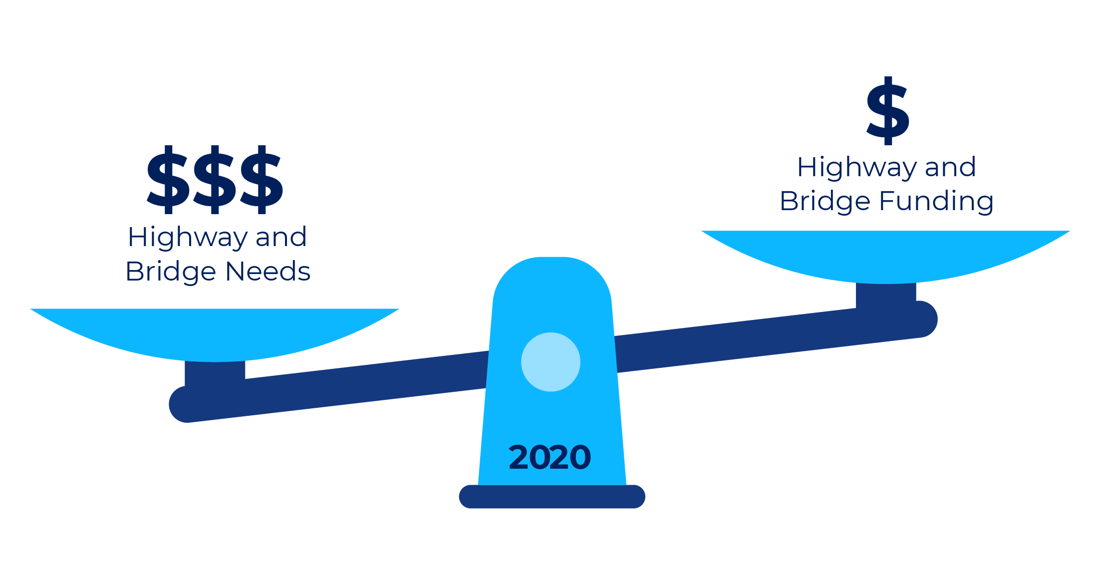
PennDOT currently faces an $8.1 billion gap in highway and bridge funding. This means we aren't generating enough funds to properly maintain, restore and expand our transportation system. PennDOT is taking action to find reliable sources of funding through the PennDOT Pathways program.

For more information about PennDOT Pathways, visit www.penndot.gov/funding.

To support PennDOT Pathways, a Planning and Environmental Linkages (PEL) study was conducted to identify near- and long-term funding solutions and establish a methodology for their evaluation. One of the funding solutions identified was the implementation of bridge tolls on major bridge projects across the state. The I-80 Nescopeck Creek Bridges Project is one of several projects being evaluated as a candidate for bridge tolling as a part of the PennDOT Pathways Major Bridge P3 Initiative. You can learn more about the program and initiative at the link above.

A bridge toll is a fee that drivers pay when using a specific bridge, often by using a service like E-ZPass. The funds received from this toll would go back to the I-80 Nescopeck Creek Bridges to pay for their construction, maintenance and operation.

Toll Implementation

Based on feedback received from the public and at stakeholder workshops, and because of the close proximity of the two candidate bridges on the western end of I-80 and the two on the eastern end, PennDOT has decided to pursue one-way tolling on four bridge projects: Nescopeck, Lehigh River, Canoe Creek and North Fork. Traffic would be tolled westbound at Nescopeck and eastbound at Lehigh River, westbound at North Fork and eastbound at Canoe Creek, Tolls are expected to be $1-$2 for passenger cars using E-ZPass at each toll location. The one-way tolling will reduce overall diversions and reduce the need for additional tolling infrastructure to be built.

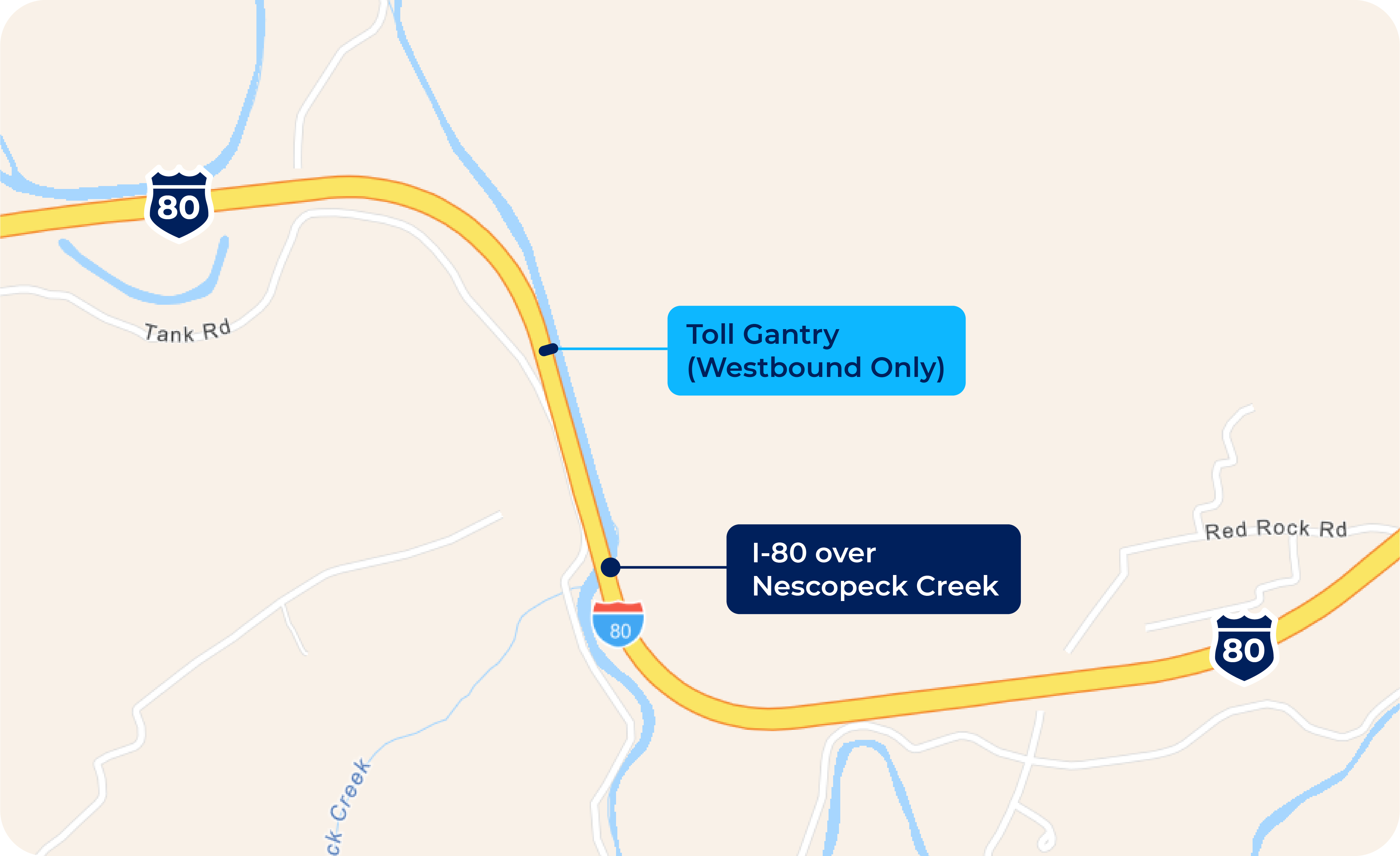
At the Nescopeck Creek Bridges project, the proposed tolling facility would be constructed along the westbound direction of I-80 about a half-mile west of the new Nescopeck Creek Bridges, and it would require the installation of a small driveway/parking area along the shoulder for maintenance and access. The tolling facility would not require drivers to stop to pay a toll when using the bridge but will record vehicles as they pass under the gantry sensor. A map of the toll gantry location is below.

In addition, signs will be placed about 1 mile prior to the tolling facility to the east to inform drivers about the toll bridge, as well as at Exit 256 near Conyngham and its respective local roadway network, to notify drivers about the toll bridge.

Exact tolling amounts will be determined once design plans are finalized so the toll would generate enough revenue for the bridge's replacement and maintenance for a period of approximately 30 years. At the end of the 30-year term for the Public Private Partnership (P3), the tolling facility would be removed.

Qualifying emergency vehicles would be permitted to use Pathways' bridges at no cost, following the Pennsylvania Turnpike Policy (PDF).

It is expected that toll collection on the bridge would begin between 2023 and 2025.

Two curved metal pipes with tolling camera devices extend over a highway.
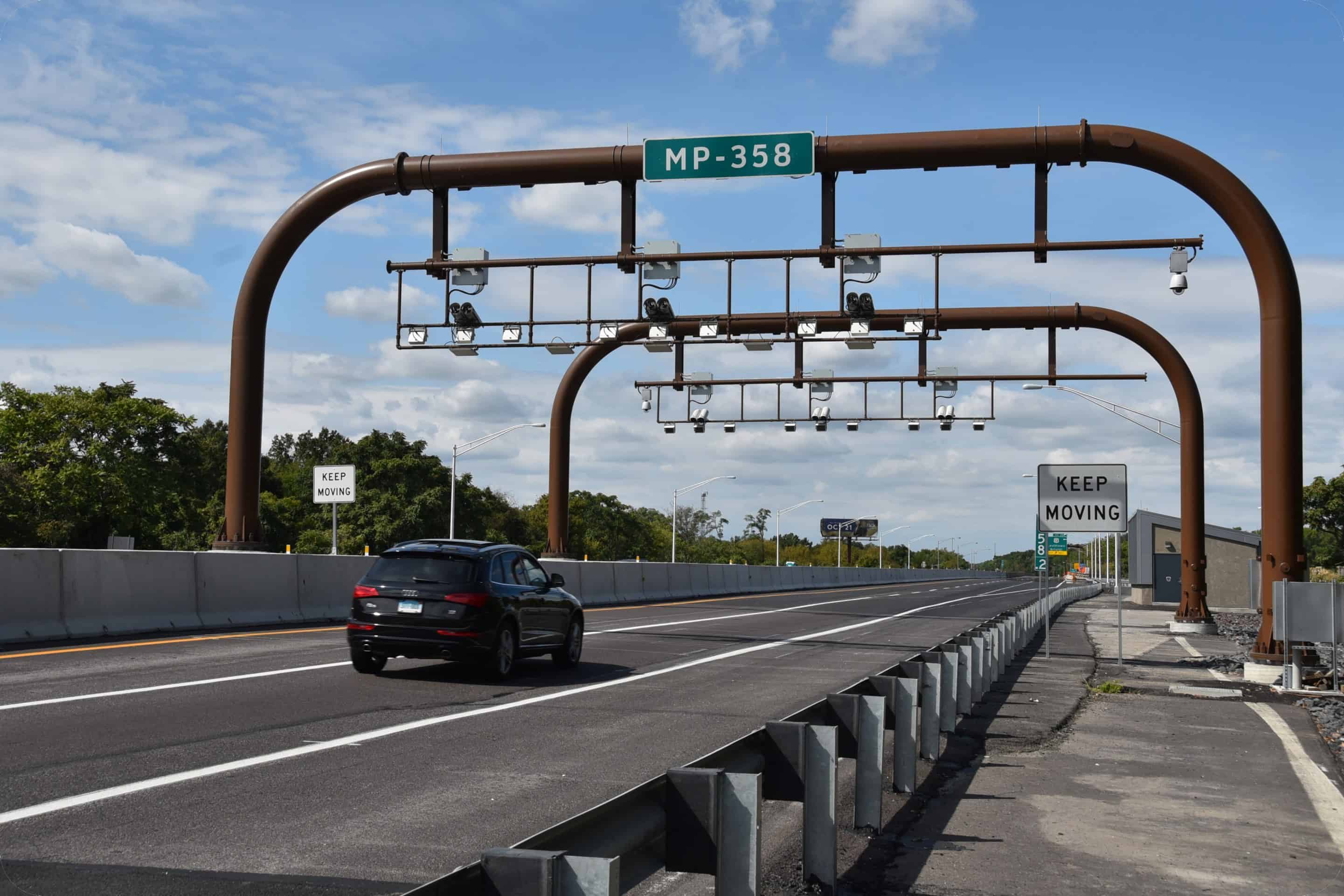
An example of an interstate toll gantry.

Environmental Studies & Mitigation

Categorical Exclusion

A Categorical Exclusion (CE) is a detailed study into how a project would affect the surrounding community's quality of life, including your health, safety, cultural resources, natural resources and more. A CE evaluation is being prepared for the I-80 Nescopeck Creek Bridges Project to address the requirements of the National Environmental Policy Act (NEPA) as it is considered for bridge replacement and tolling through the PennDOT Pathways program.

Your input is an important component of this CE evaluation. The public is encouraged to provide comments during this public meeting comment period.

Section 106 (Cultural Resources)

Section 106 of the National Historic Preservation Act requires identification of, and assessment of effects on, historic properties and archaeological sites listed on, or eligible for listing on, the National Register of Historic Places (NRHP). Consultation with persons interested in the historic and archaeological properties/sites is integral to the Section 106 process and the project's public involvement. The Section 106 process includes identifying an area of potential effect (APE) for the project, and inviting property owners within that APE, as well as historical societies and others to participate in the Section 106 process as "Consulting Parties." Separate APEs are established for the archaeological investigations and for above-ground historical properties.

These investigations are currently underway for the I-80 Nescopeck Creek Bridges Project.

Wetland and Waterways Impacts

Wetland and waterway impacts were studied as a part of the Categorical Exclusion environmental studies for the project. Overall, a few intermittent and perennial streams were observed along the Study Area; namely Nescopeck and Black Creeks as well as a few other unnamed tributaries to Nescopeck Creek. A few wetlands were also observed along the edge of Nescopeck Creek.

For the bridge replacement over Nescopeck Creek, the proposed construction activities will result in:

Permanent Temporary
Wetland Impacts 0.052 acres 0.12 acre
Stream Impacts 444 linear feet 732 linear feet

Nescopeck Creek is listed as an Approved Trout Water by the Pennsylvania Fish and Boat Commission (PFBC). Therefore, in-stream work restrictions will be required between March 1 to June 15, unless a waiver is obtained.

Alongside the road embankments of I-80 and local roadways at Exit 256 where new advance tolling signs would be placed, a few freshwater wetlands were found but all would be avoided by the proposed project.

Overall, the proposed project would result in minor permanent impacts to Nescopeck Creek and its abutting freshwater wetlands during the construction of the new bridge structures, and all temporary impacts would be restored in-kind after construction. The above in-stream work window restrictions would be followed by the contractor to avoid/minimize impacts to trout fishing. Finally, it is anticipated that minor stream and wetland mitigation requirements (offsite banking or onsite restoration) would be required by USACE or PADEP during final design and permitting.

Threatened & Endangered Plants & Animals

In studies of threatened and endangered plants and animals within the project area, potential habitat for Indiana Bat was identified with the Study Area. As such, the US Fish & Wildlife Service (USFWS) prescribed any tree cutting activities to only occur during the period between November 15 and March 31.

Traffic Diversion Analysis

Traffic diversion analysis is comprised of two distinct steps. The first is the development of the traffic model to predict how much traffic will divert off the interstate when a toll is imposed and what route that traffic will take. The second step is evaluating and analyzing the diversion routes identified to determine the impact of the diverted traffic on that route and to identify improvements to offset those impacts where appropriate.

A detailed traffic demand model was used to identify diversion routes. The existing statewide demand model that was employed is based on assumptions involving the transportation system, regional demographics and traveler characteristics. These assumptions were then combined using data from traffic counts (including the share of truck traffic), recorded travel speeds and origin and destination patterns, along with regional travel demand models. The model is then run under various parameters to predict the amount of traffic that will be diverted off the interstate and more importantly, where that traffic will go.

If a toll is placed on the I-80 Nescopeck Creek Bridges, an estimated 2 percent of daily traffic is expected to choose to divert off the interstate to avoid paying the toll, based on the results of the detailed traffic model. The model was also used to analyze what routes they would predominantly take. As mentioned above, based in part on feedback received from the public and stakeholders, PennDOT has decided to pursue one-way tolling for the four I-80 bridges and would only collect tolls on the westbound lanes at Nescopeck.

So where would the majority of the diverting traffic go? The primary diversion route identified for the Nescopeck Project is SR 93 for the eastern portion of the diversion and US Route 11 for the western portion of the diversion. This route is shown on the map below. You can click on the map to enlarge it.

Click to view map larger.

As you can see from the table below, the AM and PM Peak Hour traffic on the bridge will be reduced by approximately 60-70 vehicles per hour, and the primary diversion route will increase by approximately 40-50 vehicles per hour. The remaining diverted traffic will utilize a variety of other routes, but those routes will not be substantially impacted given the amount of traffic predicted to use them.

Route Time of Day Pre-Toll Traffic Post-Toll Traffic
Primary Diversion Route AM Peak Hour 580 620
Primary Diversion Route PM Peak Hour 710 760
I-80 Nescopeck Creek Bridges AM Peak Hour 2,570 2,510
I-80 Nescopeck Creek Bridges PM Peak Hour 3,430 3,360

The origin-destination patterns are also taken into account in looking at diversion. The origin-destination criteria is divided into three categories: local (less than 10 miles), regional (10-25 miles) and external (more than 25 miles). As you can see in the graphic below, the majority of the traffic traveling over the bridges originates from external locations and is destined to external locations. Because these trips are typically long-distance trips, this type of traffic is more likely to stay on the interstate and not divert.

When people hear about vehicles diverting from the interstate to avoid a tolled bridge, they often envision what happens when there is a full traffic detour. To distinguish between a diversion and a detour in simple terms, diversions are a choice, detours are mandatory.

Detours are imposed because of construction or an incident on a roadway or bridge and those detours must be followed. In contrast to a detour, diversion from the interstate is a choice that drivers may make to avoid a toll and the diversion traffic is normally a small fraction of the number of vehicles compared to detours, when 100 percent of traffic leaves the interstate.

Traffic Diversion Methodology

Once it was determined how much traffic would divert and the primary route that would be utilized, a comprehensive evaluation of the potential impacts to the diversion route was undertaken. The graphic below highlights the key methodology for the evaluation of the diversion route.

Route Identification
Prioritize routes that add more than 100 vehicles per day
Traffic Projections
No toll vs. tolling scenario comparisons
Route Conditions
Intersections, traffic control, signage, & pavement conditions
Crash Data Summary
Identify crash patterns & crash rates
Capacity Analysis
Depict operational issues & capacity limitations
Roadway Review
Evaluation of lane widths and pavement structure
Alternative Transportation Modes
Transit, bus, bike lanes, etc.
Potential Mitigation Options
Evaluation of options to offset impacts to community

A workshop was conducted with key stakeholders (including elected officials, first responders, school districts, regional planners, etc.) in July 2021 to discuss the diversion route analysis, collect information on additional routes drivers might take and potential impacts from diverting traffic. This feedback was incorporated into the traffic diversion analysis and evaluated to identify potential ways PennDOT could mitigate impacts on the community caused by the toll diversion. At the workshop, some stakeholders did express concern in the diversion route that SR 339 is likely to be a heavier used diversion route than US Route 11 for the western portion of the diversion route. The analysis and recommended improvements to off-set effects are shared below.

Traffic Evaluation

An extensive traffic study was conducted of the primary diversion route, as well as the SR 339 route mentioned at the diversion workshop, including field observations and stakeholder coordination, traffic counts, capacity analysis, and crash analysis.

Field Observation

Field observations included travel time measurements on I-80 and along the diversion routes, observations of travel time and congestion, and evaluation of signage and pavement conditions along portions of the diversion route.

Stakeholders

Concerns were also expressed by stakeholders over the expected use of SR 339, as noted previously, as well as the operation of the intersection of SR 93 and the I-80 WB off ramps, due to the heavy use of trucks utilizing the rest stop. The access to the rest stop, Old Berwick Road, forms the fourth leg of the intersection, although offset from the I-80 WB off ramp by approximately 100 feet.

Traffic Counts

Intersection turning movement counts were conducted at 21 intersections along the primary diversion route as shown on the Diversion Route Map, with an additional 4 intersections conducted along SR 339, during the AM Peak, midday, and PM peak periods. These 25 intersection counts included separate tabulations of pedestrians, motorcycles, cars, trucks, medium trucks and heavy trucks. Video was taken during the counts to document traffic operations.

Capacity Analysis

Capacity analysis was conducted of these 25 intersections using the Highway Capacity Manual methodology in the Synchro analysis software. Estimated 2023 traffic volumes were projected based upon the counts and regional growth factors. Increased traffic along the primary diversion route following the implementation of tolling was estimated using the Statewide Traffic Model. The capacity analysis indicated that all of the signalized study area intersections are projected to operate at overall LOS C or better, a low level of congestion, in the future. Additionally, all study area intersections are projected to operate at LOS D or better for all movements, again indicative of acceptable operation.

Crash Analysis

The crash analysis looked at five years' data of reported crashes throughout the study area. Multiple crash clusters have been noted throughout the study area, which is not unexpected given the volumes of traffic and number of conflicting movement throughout the area. The largest clusters are primarily noted at the intersection of SR 93 and the I-80 WB off ramps, and at the closely spaced signalized intersections along US Route 11 in Berwick.

Key Issues

Through input provided at the diversion workshop and through the traffic analysis and crash evaluation, several issues have been identified throughout the project study area. The following is a listing of the major identified issues.

  • SR 93 and I-80 WB Off Ramp
    • High crash volume.
    • Traffic congestion extending along SR 93 when crashes occur.
    • Overall traffic operational issues.
    • High heavy truck volume.
  • Barletta Quarry along SR 93
    • Traffic behind slow moving heavy vehicles on upgrades causing traffic congestion.
  • US Route 11 Traffic Signal Coordination
    • Traffic stopping at multiple traffic signals along corridors causing delays.
  • Nescopeck Township Local Roads
    • Heavy vehicles getting stuck on local roads that are not designed to carry them needing local emergency service assistance to get freed.

Diversion Route Improvements

Based on feedback received during outreach and the subsequent analyses, numerous improvements were evaluated and are detailed below. Because modeling forecasts can sometimes differ from actual impacts, before and after studies will be conducted on the diversion routes. These studies will confirm the models' results or identify areas where additional evaluations should be conducted to identify improvements for consideration and potential implementation.

Based upon detailed evaluation of issues identified by project stakeholders, the following improvements along the diversion route are proposed to accommodate the effects of tolling diversion:

  • Installation of a traffic signal at the SR 93/WB Off Ramp intersection, including realignment of the WB Off Ramp to intersect SR 93 directly opposite Old Berwick Road, and install signal ahead sign on SB SR 93 approach, timed to flash red when traffic signal is to turn red for that approach.
  • Construction of a WB acceleration lane along SR 93, to the west of the Barletta Quarry, extending for a length of approximately 1,000 feet, to allow quarry trucks to accelerate to the speed of SR 93 WB traffic before merging into the traffic stream.
  • Review overall signal coordination of traffic signals along US Route 11 within Berwick and provide updates/improvements.
  • Overall review of directional signing to I-80 and truck restriction signage for the local roadways south of Nescopeck Borough.
  • Conduct before/after study of intersection operations.

Note: The analysis showed while some diversion traffic will likely utilize SR 339, particularly those familiar with the area, the volume of traffic potentially diverting to the SR 339 corridor can be accommodated without the need for any additional improvements.

Click to view map larger.

Environmental Justice Considerations

Executive Order 12898, Federal Actions to Address Environmental Justice in Minority and Low-Income Populations (February 11, 1994), directs federal agencies to identify and address, as appropriate, disproportionately high and adverse human health or environmental effects of programs, policies and activities on minority and low-income populations.

  • Low-income is defined as a person whose median household income is at or below the Department of Health and Human Services federal poverty guidelines ($26,500 for a household of four).
  • Minority is a person who is: (1) Black (2) Hispanic or Latino (3) Asian American (4) American Indian and Alaskan Native, or (5) Native Hawaiian and Other Pacific Islander.

Implementation of a toll would affect all bridge users regardless of income and minority status. Because tolls would comprise a larger percentage of a low-income bridge user's income, tolls would have a greater effect on these users, particularly if they depend on the bridge for daily travel to work or other destinations. As a result, and in keeping with other Department of Human Services (DHS) financial assistance programs offered in Pennsylvania (SNAP, Medicaid, LIHEAP), PennDOT is proposing to offer toll-free bridge access to low-income persons qualifying for one or more of these DHS programs. The DHS financial assistance programs use a progressive income limit based on the number of people in a household (equivalent to about $35,000 for a family of four — but it varies slightly by DHS program). Individuals who qualify for toll-free bridge access would select one toll bridge from the Major Bridge P3 Initiative to apply these benefits.

Preliminary analysis, U.S. Census data, and information received from PennDOT outreach initiatives indicate that low-income populations may live along the traffic diversion route (SR 93 and US Route 11). As indicated in the Traffic Diversion Analysis section above, PennDOT would make minor roadway improvements to minimize effects on the diversion route.

Nevertheless, PennDOT is seeking participation by potentially affected communities to understand how the effects of increased traffic may impact low-income and minority populations. You are encouraged to contribute to our understanding of local conditions by submitting your comments during the comment period.

Project Schedule

The project's next step is to complete the environmental studies and prepare the Categorical Exclusion environmental document for the project.

Here, you can see an estimated timeline of the project's major milestones: