Begin Main Content Area

 Content Editor

PennDOT Pathways I-81 Susquehanna Project Virtual Public Meeting - November 2021

I-81 Susquehanna Project

Virtual Public Meeting

This page is best viewed in Chrome, Edge or Firefox.

PennDOT welcomes you to the Virtual Public Meeting for the I-81 Susquehanna Project. Click the video below for an introduction to the project:

Click here to download a PDF transcript of the video.

Thank you for joining us for this Virtual Public Meeting to learn more about the I-81 Susquehanna Project (also known as the "SR 81 Section 511 Interstate Reconstruction Project"). Since our last public meeting in July 2021, we are here today to provide information about the project's latest design plans and impacts as they relate to the proposed bridge tolling implementation, diversion routes, mitigation, and schedule.

You can access this meeting anytime between noon on Nov. 8 and 11:59 p.m. Dec. 8, 2021, at your convenience.

We encourage comments on the project. Comments will be accepted through Dec. 8 when the meeting closes. Comments may be submitted via the comment form at the bottom of this meeting's web page, via email to i81Susquehanna@pa.gov, by leaving a message on our hotline at (570) 892-4004 or by sending a letter to PennDOT District 4, Attn: I-81 Susquehanna Project, 55 Keystone Industrial Park, Dunmore, PA 18512.

How To Navigate This Meeting

To advance to the next portion of the meeting, scroll down or use the navigation bar at the top of the page to revisit any part of the meeting.

Project Overview

The Susquehanna Project

The I-81 Susquehanna Project is a 9-mile corridor reconstruction and repair project along Interstate 81 from the New Milford Interchange with SR 492 (Exit 223) through the Great Bend Interchange with SR 171 (Exit 230) to the New York border. This section of I-81 was originally constructed in 1961.

The I-81 bridges over the Susquehanna River are dual structures (one northbound and one southbound) that were built in 1961 and rehabilitated in 1979, 1993 and 2006. They cross the river between the boroughs of Hallstead and Great Bend and their replacement is at the heart of this corridor project. Combined, the bridges carry about 27,000 vehicles per day, approximately 41 percent of which is truck traffic. The combined daily traffic is expected to more than double by 2045 to around 55,000.

Along the balance of this 9-mile corridor, an additional series of roadway, drainage and structural bridge improvements are being proposed — which are further discussed below.

Study Area Map

The study area for the Susquehanna Project extends approximately 9 miles on I-81 from New Milford Borough to the New York border.

Purpose & Need

The purpose of the Susquehanna Project is to provide safe and reliable travel on the I-81 corridor, including the crossing over the Susquehanna River, and to address aging pavement and infrastructure.

We've identified several needs this project is intended to address:

Aging Infrastructure

Most of the pavement in the corridor is nearly 60 years old, and the Susquehanna River bridges are approaching the end of their serviceable lifespan.

Outdated Interchange Designs

The on- and off-ramps at the interchanges throughout the corridor do not meet current and future traffic design standards.

Outdated Construction Methods

All structures in the corridor were constructed with reinforced concrete that contains more chloride ion content than modern standards allow. While safe, this type of reinforced concrete has a shorter lifespan than most reinforced concrete used today.

Drainage Concerns

The storm system built into much of the corridor has exceeded its serviceable lifespan.

Where We Are Now

Through the National Environmental Policy Act (NEPA) environmental review process, the I-81 Susquehanna Project was approved as a Categorical Exclusion (CE) in 2018 (See explanation below in Environmental Studies & Mitigation section), and the project team then moved forward with final design.

When the CE was originally completed for the project, a plans display and public meeting was held on July 20, 2017, at the Great Bend Township Hose Company No. 1. No substantial public concerns were raised during this outreach process.

As the project design was being finalized, changes in the design necessitated the need for a reevaluation. That CE reevaluation process, which included a separate virtual public plan display from July 1, 2021 to July 15, 2021 (see its public webpage for the details of these changes), is now completed.

Today, PennDOT is re-evaluating the CE for this project because it is one of several that are being evaluated as a candidate for bridge tolling. More information on bridge tolling and the PennDOT Pathways program can be found below.

As part of the CE reevaluation, PennDOT is analyzing how bridge tolling might affect local communities and how the alternate routes drivers could take to avoid the toll might impact local traffic and roadways.

The project is currently in final design. Construction is anticipated to begin between 2023 and 2025.

Project Design

The project includes the replacement of several bridges; new pavement, guide rails, signs and drainage system; and lengthening on- and off-ramps between mile marker 223.84, just north of the New Milford Interchange, and the New York border at mile marker 232.7.

Overall, the project involves a number of construction activities, including:

  • Repaving all roadway in the corridor
  • Replacing five dual bridge structures, including the bridges over the Susquehanna River and the SR 1029 (Randolph Road) overpass structure (see map insert)
  • Replacing the drainage system
  • Replacing all guide rails, barriers and signage in the corridor
  • Construction work on Susquehanna Street, SR 171 and SR 1029 (Randolph Road)
  • Local roadway relocation of Emerson Road
  • Rehabilitation work on deteriorated concrete at two box culverts and replacement of a third culvert

Two lanes of traffic in both directions on I-81 would be maintained during construction. A total of five discrete and temporary detours would be required as a result of construction work on the on/off ramps and local roads.

The two Interstate 81 bridges extend over an icy Susquehanna River.
I-81 crossing over the Susquehanna River

Bridge Tolling

Funding

The estimated cost of construction for the I-81 Susquehanna Project is between $175 million and $200 million.

PennDOT Pathways is a program to identify and implement alternative funding solutions for Pennsylvania's transportation system. As Pennsylvania's mobility needs have grown, the amount of funding required to support our transportation system has continued to increase. Much of our current funding comes from gas taxes and driver and vehicle fees. While this model worked well in the past, circumstances today have made it unsustainable. With PennDOT Pathways, we're looking for reliable, future-focused funding solutions that will meet our growing needs while serving our communities and all Pennsylvanians for generations to come.
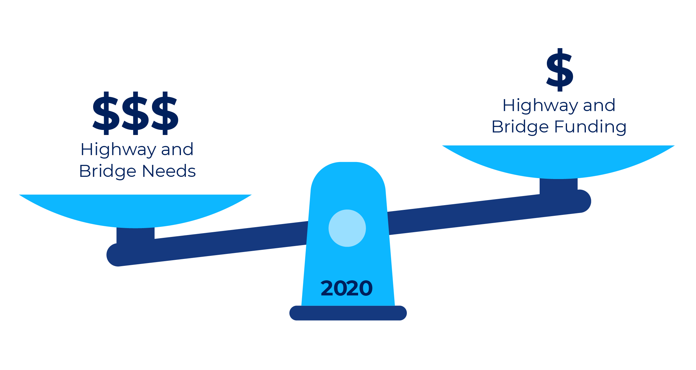
PennDOT currently faces an $8.1 billion gap in highway and bridge funding. This means we aren't generating enough funds to properly maintain, restore and expand our transportation system. PennDOT is taking action to find reliable sources of funding through the PennDOT Pathways program.

For more information about PennDOT Pathways, visit www.penndot.gov/funding.

To support PennDOT Pathways, a Planning and Environmental Linkages (PEL) study was conducted to identify near- and long-term funding solutions and establish a methodology for their evaluation. One of the funding solutions it identified as being able to implement immediately is tolling on major bridge projects across the state. The I-81 Susquehanna Project is one of several projects being evaluated as a candidate for bridge tolling as a part of the PennDOT Pathways Major Bridge Public-Private Partnership Initiative (MBP3I). You can learn more about the program and initiative at the link above.

A bridge toll is a fee that drivers pay when using a specific bridge, often by using a service like E-ZPass. The funds received from the bridge toll would go back to the I-81 Susquehanna Project to pay for its construction, maintenance, and operation.

Toll Implementation

To implement the toll with All-Electronic Tolling (such as E-ZPass or toll-by-plate), a tolling facility (gantry, building and utilities) would be constructed within the Great Bend Interchange (Exit 230), 800 feet north of the I-81 Bridges over the Susquehanna River, and would require the installation of a small driveway/parking area along the shoulder for maintenance and access. The tolling facility would not require drivers to stop to pay a toll when using it but would record vehicles as they pass under the gantry sensor. A map of the toll gantry location is below.
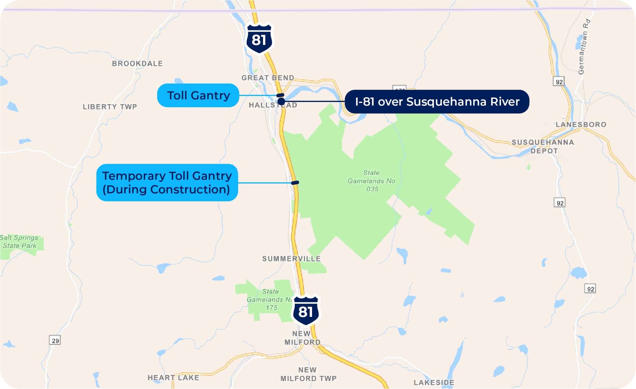
As tolling would be implemented at the on-set of project construction, a temporary tolling facility would first be built about two miles south of the Susquehanna River to avoid construction/traffic staging conflicts during construction. This temporary tolling facility would include the same features as the permanent one described above.

In addition, signs would be placed about one mile prior to the nearest exits in each direction — Exits 230 and 223 — as well as along the local roadway network, to notify drivers about the toll bridge.

PennDOT has established that tolls on the candidate bridges, including the I-81 Susquehanna Project, would be in the range of $1-$2 for cars using E-ZPass and higher for toll-by-plate and for medium or heavy trucks. Exact tolling amounts would be determined once design plans are finalized so the toll would generate enough revenue for the bridges' replacement, operations and maintenance for a period of approximately 30 years. At the end of the 30-year term for the Public-Private Partnership (P3), the tolling facility would be removed.

Qualifying emergency vehicles would be permitted to use Pathways' bridges at no cost, following the Pennsylvania Turnpike Policy (PDF).

It is expected that toll collection on the bridge would begin between 2023 and 2025.
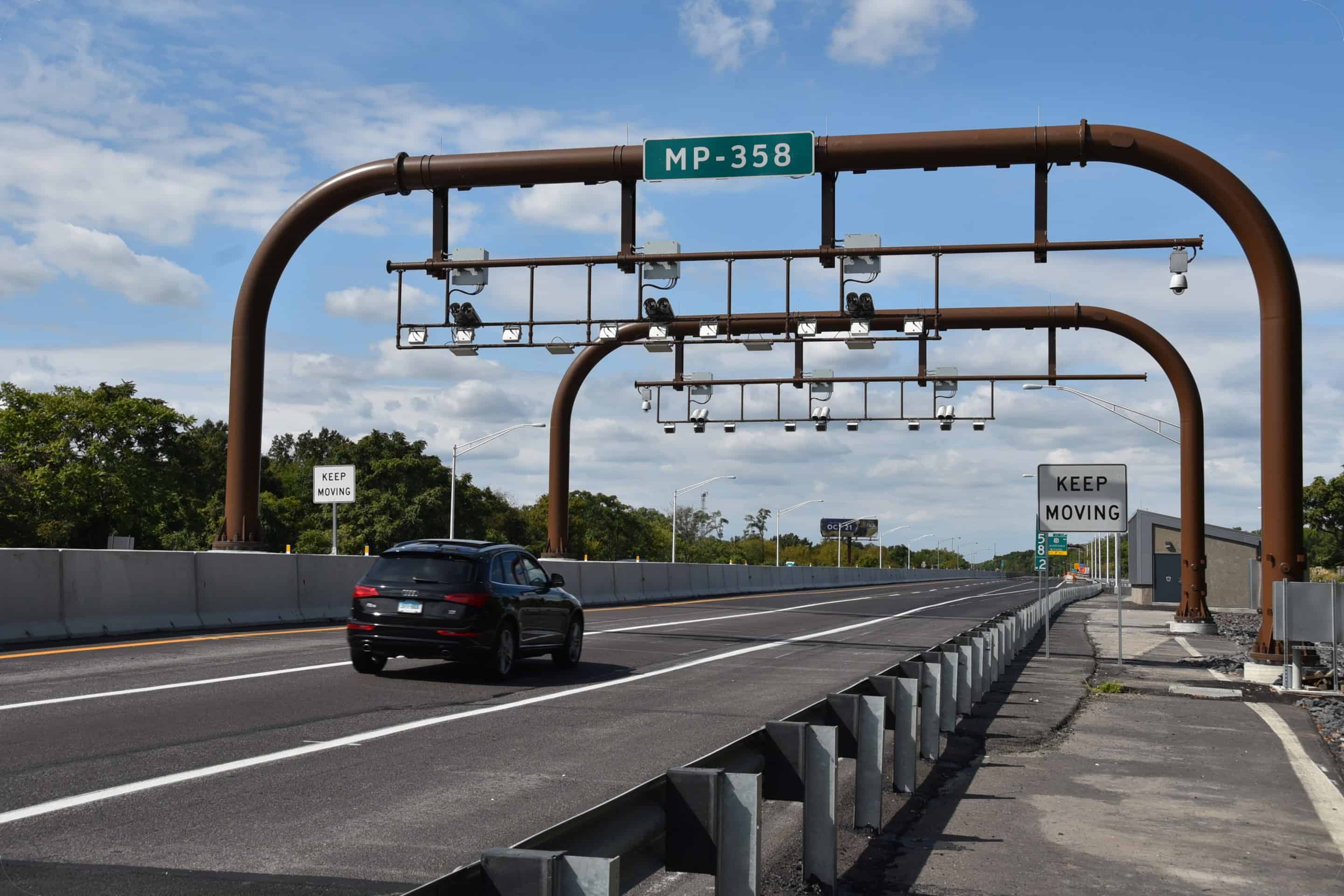
Two curved metal pipes with tolling camera devices extend over a highway.
An example of an interstate toll gantry.

Environmental Studies & Mitigation

Categorical Exclusion

A Categorical Exclusion is a detailed study into how a project would affect the surrounding community's quality of life, including health, safety, cultural resources, natural resources and more. A reevaluation of the CE is being prepared for the I-81 Susquehanna Project to address the requirements of the National Environmental Policy Act (NEPA) as the project is considered for bridge tolling through the PennDOT Pathways program.

Your input is an important component of this CE reevaluation. The public is encouraged to provide comments during this public meeting comment period.

Section 106 (Cultural Resources)

Section 106 of the National Historic Preservation Act is applicable to federal agencies and requires identification of, and assessment of effects on, historic properties and archaeological sites listed on, or eligible for listing on, the National Register of Historic Places (NRHP). Consultation with persons interested in the historic and archaeological properties/sites is integral to the Section 106 process and the public's involvement in the project. The Section 106 process includes identifying an area of potential effect (APE) for the project, and inviting property owners within that APE, as well as historical societies and others, to participate in the Section 106 process as "Consulting Parties." Separate APEs are established for the archaeological investigations and for above-ground historical properties.

This project would not result in any adverse effects to any archeological resources or historic properties. During the Section 106 consultation, some design modifications were implemented to avoid an adverse effect to one rchaeological site and avoid any staging, right-of-way acquisition or temporary construction easements on the related property, just south of Susquehanna River.

Wetland and Waterways Impacts

Wetland and waterway impacts were studied as a part of the Categorical Exclusion environmental studies for the project. The following impacts were identified.

Streams, Rivers & Watercourses Presence Impacts
Intermittent & Perennial Streams Present 450 linear feet
Wild Trout Streams Not Present None
Stocked Trout Streams Present 330 linear feet
Federal Wild & Scenic Rivers & Streams Not Present None
State Scenic Rivers & Streams Not Present None
Coast Guard Navigable Waterways Not Present None
Pennsylvania Fish & Boat Commission Water Trail Present 610 linear feet on Susquehanna River

Smith Creek, Salt Lick Creek, Trowbridge Creek and the Susquehanna River were identified in the immediate project area. Permanent impacts to these waterways include 450 linear feet. There would be 1,180 linear feet of temporary stream impacts during construction.

Smith Creek and Salt Lick Creek are designated as "Stocked Trout Streams." As such, no work would be permitted in the stream from March 1 to June 15. In addition, the proposed project mitigation will include stream cleaning and regrading of Trowbridge Creek for approximately 450 linear feet.

An Aids to Navigation (ATON) Plan will be developed to minimize impact to recreational boaters on the Susquehanna River.

Wetlands Presence Impacts
Open Water Present 0.71 acre (permanent)

0.84 acre (temporary)
Vegetated Emergent Present
Vegetated Scrub Shrub Present
Vegetated Forested Present
Exceptional Value Not Present None

Field investigations identified and delineated wetlands within the project study area. There will be permanent impacts to 35 wetland areas as a result of the project. The total acreage of these impacts is 0.71 acres.

Wetland mitigation would entail the purchase of 1.1 credits from an authorized mitigation bank.

Threatened & Endangered Plants & Animals

Upon consultation with the Pennsylvania Fish and Boat Commission (PFBC), concerns were raised with the possible presence of the elktoe mussel species within the Susquehanna River. As such, the PFBC requested continued consultation during final design and construction to better ascertain the need to possibly perform a mussel survey and relocation effort for any specimens that would be impacted by construction. Such PFBC determination would be based on the proposed in-stream construction schedule. PFBC would be notified/consulted at least nine months prior to commencing in-stream construction activities within the Susquehanna River.

Traffic Diversion Analysis

Traffic diversion analysis is comprised of two distinct steps: The first is the development of the traffic model to predict how much traffic would divert off the interstate when a toll is imposed and what route that traffic would take. The second step is evaluating and analyzing the diversion routes identified to determine the impact of the diverted traffic on that route and to identify improvements to offset those impacts where appropriate.

A detailed traffic demand model was used to identify diversion routes. The existing statewide demand model that was employed is based on assumptions involving the transportation system, regional demographics and traveler characteristics. These assumptions were then combined using data from traffic counts (including the share of truck traffic), recorded travel speeds and origin and destination patterns, along with regional travel demand models. The model is then run under various parameters to predict the amount of traffic that will be diverted off the interstate and more importantly, where that traffic will go.

If a toll is placed on the Susquehanna Bridge, an estimated 6 percent of daily traffic is expected to choose to divert off the interstate to avoid paying the toll, based on the results of the detailed traffic model. The diverting traffic would be predominantly passenger vehicles and small trucks. The model was also used to analyze what routes they would predominantly take.

So where would the majority of the diverting traffic go? The primary diversion route identified in the model is along State Route 171, U.S. Route 11 and State Route 492. This route is shown on the map below. You can click on the map to enlarge it.

Click to view map larger.

As you can see from the table below, with the toll in place the AM and PM peak hour traffic on the bridges would be reduced by approximately 100 to 200 vehicles per hour, and the primary diversion route would increase by approximately 80 to 130 vehicles per hour, with the remainder of traffic expected to use other routes.

Route Time of Day Pre-Toll Traffic Post-Toll Traffic
Primary Diversion Route AM Peak Hour 480 560
Primary Diversion Route PM Peak Hour 660 790
I-81 Susquehanna AM Peak Hour 2,100 2,000
I-81 Susquehanna PM Peak Hour 3,200 3,000

The origin-destination patterns are also taken into account in looking at diversion. The origin-destination criteria is divided into three categories: local (less than 10 miles), regional (10-25 miles) and external (more than 25 miles). As you can see in the graphic below, the majority of traffic traveling over the bridges originates from external locations and is destined to external locations. Because these trips are typically long-distance trips, this type of traffic is more likely to stay on the interstate and not divert.

When people hear about vehicles diverting from the interstate to avoid a tolled bridge, they often envision what happens when there is a full traffic detour. To distinguish between a diversion and a detour in simple terms, diversions are a choice, detours are mandatory.

Detours are imposed because of construction or an incident on a roadway or bridge and those detours must be followed. In contrast to a detour, diversion from the interstate is a choice that drivers may make to avoid a toll and the diversion traffic is normally a small fraction of the number of vehicles compared to detours, when 100 percent of traffic leaves the interstate.

Traffic Diversion Methodology

Once it was determined how much traffic would divert and the primary route that would be utilized, a comprehensive evaluation of the potential impacts to the diversion route was undertaken. The graphic below highlights the key methodology for the evaluation of the diversion route.

Route Identification
Prioritize routes that add more than 100 vehicles per day
Traffic Projections
No toll vs. tolling scenario comparisons
Route Conditions
Intersections, traffic control, signage, & pavement conditions
Crash Data Summary
Identify crash patterns & crash rates
Capacity Analysis
Depict operational issues & capacity limitations
Roadway Review
Evaluation of lane widths and pavement structure
Alternative Transportation Modes
Transit, bus, bike lanes, etc.
Potential Mitigation Options
Evaluation of options to offset impacts to community

A workshop was conducted with key stakeholders (including elected officials, first responders, school districts, regional planners, etc.) on July 27, 2021, to discuss the diversion route analysis, collect information on additional routes drivers might take and potential impacts from diverting traffic. This feedback was incorporated into the traffic diversion analysis and evaluated to identify where toll diversion may cause adverse effects and examine potential ways to offset these impacts. The analysis and recommended improvements are shared below.

Traffic Evaluation

An extensive traffic study was conducted of the primary diversion route, including field observations and stakeholder coordination, traffic counts, capacity analysis, and crash analysis.

Field Observation

Field observations included:

  • Travel time measurements on I-81 and along the diversion route
  • Observations of travel time and congestion, along with field sight distance measurements
  • Observations of traffic patterns.
Stakeholders

Concerns about the project area discussed during stakeholder coordination for the project:

  • Local emergency responders noted concerns over tolls for EMS responders.
  • Traffic movements on SR 171 at the I-81 interchange area.
  • Delays caused by inadequate turning radii for large trucks at the US 11/ SR 492 intersection.
  • Sight distance issues with the Northbound I-81 off-ramp with SR 492 were also a concern.
Traffic Counts
  • Intersection turning movement counts were conducted at six intersections along the primary diversion route, including the I-81 ramps at SR 171 and SR 492, as shown on the Diversion Route Map, during the AM peak, midday, and PM peak periods.
  • These counts included separate tabulations of pedestrians, motorcycles, cars, trucks, medium trucks and heavy trucks.
  • Video was taken during the counts to document traffic operations.
Capacity Analysis
  • Capacity analysis was conducted at the six intersections (three at the SR 171 / US 11 intersection and interchange at I-81, the US 11 / SR 492 Jackson St intersection and two at the SR 492 / I-81 interchange).
  • Estimated 2023 and 2040 traffic volumes were projected based upon the counts and regional growth factors.
  • Increased traffic along the primary diversion route following the implementation of tolling was estimated using the Statewide Traffic Model.
  • The capacity analysis indicated that all but one intersection in the study area are projected to operate with a low level of congestion in the future.
  • Projected toll diversion traffic would result in a higher level of congestion at the US 11 (Main St) and SR 492 (Jackson St) intersection in New Milford.
Crash Analysis

The crash analysis looked at five years' worth of data on reported crashes and did not identify any above average predicted crash frequency.

Diversion Route Improvements

Based on feedback received during outreach and the subsequent analyses, numerous improvements were evaluated and are detailed below. Because modeling forecasts can sometimes differ from actual impacts, before and after tolling studies will also be conducted on the diversion routes. These studies will confirm the models' results or identify areas where additional evaluations should be conducted to identify improvements for consideration and potential implementation.

Based upon detailed evaluation of issues identified by project stakeholders, the following improvements along the diversion route are proposed to accommodate the effects of tolling diversion:

  • Updated pedestrian signal, crossing and ADA ramp, replacement of pavement markings and signs in the SR 171 / US 11 intersection along with SR 171 intersections with I-81 ramps
  • Consideration of a pedestrian crosswalk near the Post Office / Washington St area crossing US 11 (Main St)
  • Installation of a signalized intersection at the US 11 (Main St) / SR 492 (Jackson St) Intersection, subject to municipal approval. (See Draft Conceptual Plan below Improvements Map)
  • Clearing of vegetation and relocating of signs east of the I-81 northbound off-ramp / SR 492 intersection to improve sight distance.
Click to view map larger.

Environmental Justice Considerations

Executive Order 12898, Federal Actions to Address Environmental Justice in Minority and Low-Income Populations (February 11, 1994), directs federal agencies to identify and address, as appropriate, disproportionately high and adverse human health or environmental effects of programs, policies and activities on minority and low-income populations.

  • Low-income is defined as a person whose median household income is at or below the Department of Health and Human Services federal poverty guidelines ($26,500 for a household of four).
  • Minority is a person who is: (1) Black (2) Hispanic or Latino (3) Asian American (4) American Indian and Alaskan Native, or (5) Native Hawaiian and Other Pacific Islander.

Implementation of a toll would affect all bridge users regardless of income and minority status. Because tolls would comprise a larger percentage of a low-income bridge user's income, tolls would have a greater effect on these users, particularly if they depend on the bridge for daily travel to work or other destinations. As a result, and in keeping with other Department of Human Services (DHS) financial assistance programs offered in Pennsylvania (SNAP, Medicaid, LIHEAP), PennDOT is proposing to offer toll-free bridge access to low-income persons qualifying for one or more of these DHS programs. The DHS financial assistance programs use a progressive income limit based on the number of people in a household (equivalent to about $35,000 for a family of four — but it varies slightly by DHS program). Individuals who qualify for toll-free bridge access would select one toll bridge from the Major Bridge P3 Initiative to apply these benefits.

Preliminary analysis, U.S. Census data, and information received from PennDOT outreach initiatives indicate that low-income populations may live along the traffic diversion route (US Route 11). As indicated in the Traffic Diversion Analysis section above, PennDOT would make minor roadway improvements to minimize effects on the diversion route.

Nevertheless, PennDOT is seeking participation by potentially affected communities to understand how the effects of increased traffic may impact low-income and minority populations. You are encouraged to contribute to our understanding of local conditions by submitting your comments during the comment period.

Project Schedule

The project is currently in final design. The next step is to complete the environmental studies and prepare the reevaluation of the Categorical Exclusion. Construction is anticipated to begin between 2023 and 2025 with a four- to five-year construction period.