This project is one of nine that are being evaluated as a candidate for bridge tolling as a part of the Major Bridge Public-Private Partnership Initiative (MBP3). More information on bridge tolling and the PennDOT Pathways program can be found in the Bridge Tolling section of this Open House below.
PennDOT, in coordination with FHWA, is preparing EAs for the MBP3 Initiative candidate bridges in accordance with NEPA. These EAs examine the significance of potential impacts to natural, social, economic, and cultural resources from the alternative(s) under consideration. The results of the EA's environmental analysis will determine whether an Environmental Impact Statement needs to be prepared, or whether a Finding of No Significant Impacts can be issued.
The project team previously hosted public meetings on this project, online and in person in November and December 2021. Links to information presented during those meetings are available on the project website at www.penndot.pa.gov/i80LehighRiverBridge.
The project is currently in preliminary design, and construction is anticipated to begin in 2023.
Project Design
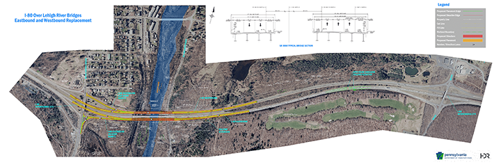
The replacement I-80 Lehigh River Bridges would span across the valley with structures having anticipated lengths of 850 feet (eastbound) and 770 feet (westbound). Several structure options were examined with consideration of cost, constructability, and future maintenance. It was found that girder structures would be the most cost-effective option for the bridge design.
To allow maintenance of traffic during construction, the new eastbound bridge will be built just south of the existing eastbound bridge. The new westbound bridge will be built on the existing westbound alignment. The acceleration lane for the eastbound on-ramp from SR 940 will be extended across the new eastbound bridge.
You can see the recommended project design below.
 Click to view design plan map larger.
Bridge Tolling
Funding
The estimated cost of construction of the I-80 Over Lehigh River Bridge Project is between $60 and $75 million.
PennDOT Pathways is a program to identify and implement alternative funding solutions for Pennsylvania's transportation system. As Pennsylvania's mobility needs have grown, the amount of funding required to support our transportation system has continued to increase. Much of our current funding comes from gas taxes and driver and vehicle fees. While this model worked well in the past, circumstances today have made it unsustainable. With PennDOT Pathways, we're looking for reliable, future-focused funding solutions that will meet our growing needs while serving our communities and all Pennsylvanians for generations to come.
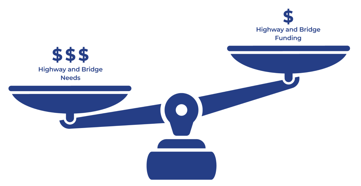
PennDOT currently faces an $8.1 billion gap in highway and bridge funding. This means we aren't generating enough funds to properly maintain, restore and expand our transportation system. PennDOT is taking action to find reliable sources of funding through the PennDOT Pathways program.
For more information about PennDOT Pathways, visit www.penndot.pa.gov/funding.
One of the funding solutions identified in the Planning and Environmental Linkages (PEL) Study was the implementation of bridge tolls on major bridge projects across the state. The I-80 Over Lehigh River Bridge Project is one of several projects being evaluated as a candidate for bridge tolling as a part of the PennDOT Pathways Major Bridge P3 Initiative. You can learn more about the program and initiative at the link above.
A bridge toll is a fee that drivers pay when using a specific bridge, often by using a service like E-ZPass. The funds received from the bridge toll would go back to the I-80 Over Lehigh River Bridge to pay for its construction, maintenance and operation.
Toll Implementation
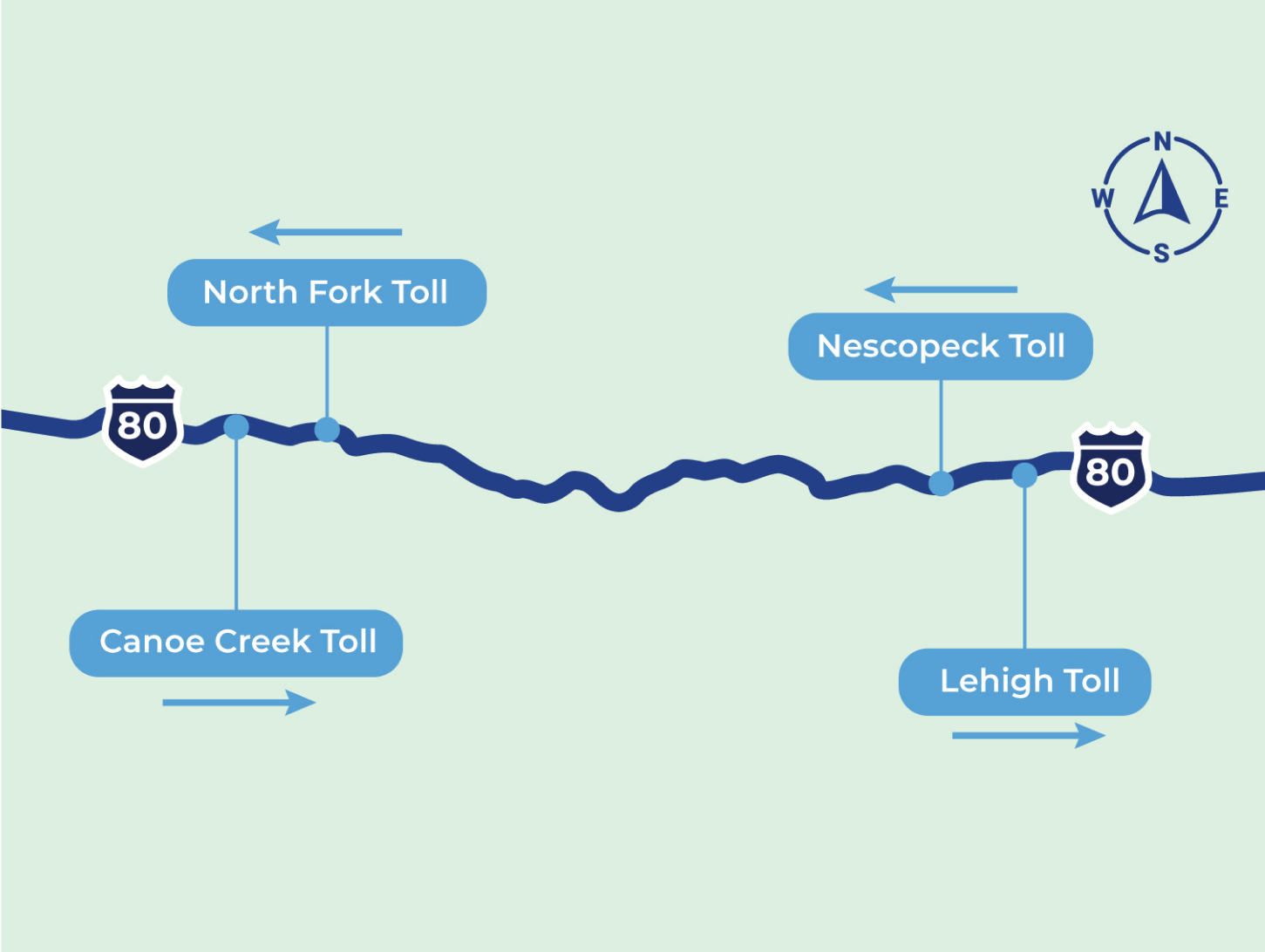
Based on feedback received from the public and at stakeholder workshops, and because of the proximity of the two candidate bridges on the eastern end of I-80 and the two on the western end, PennDOT has decided to pursue one-way tolling on four bridge projects: Lehigh River, Nescopeck, Canoe Creek and North Fork bridges. Traffic would be tolled eastbound at Lehigh River, westbound at Nescopeck, and eastbound at Canoe Creek, westbound at North Fork. Tolls are expected to be $1-$2 for passenger cars using E-ZPass at each toll location. The one-way tolling will reduce the number of tolls drivers would have to pay on I-80, as well as overall diversions and the need for additional tolling infrastructure.
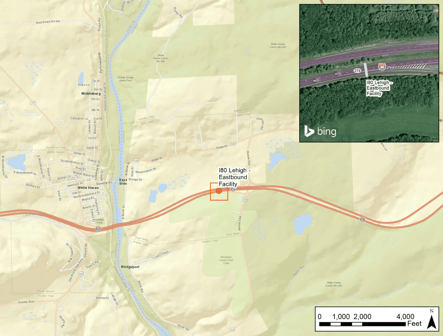
To implement the toll with All-Electronic Tolling (such as E-ZPass or toll-by-plate), a tolling gantry would be installed to collect tolls from vehicles travelling eastbound across the bridge. The gantry would not require drivers to stop to pay a toll when using the bridge but would record vehicles as they pass under the gantry sensor. The toll gantry location is shown on the map below.
Signs would be placed prior to the tolling facility to inform drivers about the toll bridge, as well as at the interchanges and along the local roadway network.
PennDOT has established that tolls on the candidate bridges, including the I-80 Over Lehigh River Bridge, would be in the range of $1-$2 for cars using E-ZPass and higher for toll-by-plate and for medium or heavy trucks. Exact tolling amounts would be determined once design plans are finalized so the toll would generate enough revenue for the bridge's replacement, operations, and maintenance for a period of approximately 30 years. At the end of the 30-year term for the Public-Private Partnership (P3), the tolling facility would be removed.
Qualifying emergency vehicles would be permitted to use Major Bridge Public-Private Parntership (MBP3) bridges at no cost, following the Pennsylvania Turnpike Policy (PDF).
It is expected that toll collection on the bridge would begin between 2023 and 2025.
 Click to view toll location map larger.
Environmental Studies
Environmental Assessment
An EA is a document that examines the significance of potential impacts to natural, social, economic and cultural resources from the alternative(s) under consideration. The EA for the I-80 Over Lehigh River Bridge Project was prepared to address the requirements of NEPA, which requires federal agencies to assess the environmental effects of their proposed actions prior to making decisions.
The results of the EA will determine whether an Environmental Impact Statement would be prepared, or a Finding of No Significant Impact would be issued.

Parks & Recreational Areas
The dual bridges carry I-80 over the Lehigh River, Lehigh Gorge State Park and Trail, Reading Blue Mountain & Northern Railroad, and River Road in White Haven Borough, Luzerne County, and East Side Borough and Kidder Township, Carbon County. Required Right-of-Way, Aerial Easements, and Temporary Construction Easements are necessary for the project, including approximately 6 acres from Lehigh Gorge State Park.
Construction of the I-80 bridges is expected to take approximately four years to complete, estimated to begin in 2023. The Department of Conservation and Natural Resources (DCNR) has broken ground on a capital improvements project in Lehigh Gorge State Park that is planned to be completed in 2022. Anticipated temporary impacts to Lehigh Gorge State Park property and the Lehigh River Water Trail are summarized below.
Lehigh Gorge Trail:
- April through October: Overnight trail closures are anticipated. Short-term trail closures are anticipated during daylight hours Monday through Friday using flaggers and advance signage.
- November through March: Long-term trail closures in the vicinity of the bridges are anticipated.
Lehigh Gorge State Park driveway and parking:
- The driveway and parking will be closed from the White Haven Shopping Center to the future park facilities south of the bridges.
- The future park entrance south of the bridges will remain open during construction, including the overflow parking area and a portion of the parking along the driveway.
Boat launches:
- The boat launch directly under the bridges will be closed during construction.
- The three future boat launches downstream of the bridge will remain open during construction.
Lehigh River Water Trail:
- Temporary causeways will extend from both riverbanks but will not completely block the river.
- An Aids to Navigation Plan will be implemented to ensure safe passage for boaters through the construction area and will include advance signing.
PennDOT will also provide replacement land as part of mitigation for Required Right-of-Way, Aerial Easement, Slope Easement, and Temporary Construction Easements within Lehigh Gorge State Park.
The majority of Lehigh Gorge State Park will remain open during bridge construction, and access to the boat launches and Lehigh River will be maintained. The contractor will restore disturbed areas, and full access to park amenities will be provided upon completion. The project will not adversely impact the recreational functions of the resources.

Lehigh River
As mentioned in the section above, a portion of the Lehigh River is within the project area. This area of the river is navigable waters and coordination with United States Coast Guard (USCG) is ongoing. This is a designated scenic river in Pennsylvania. In addition to the project utilizing robust Erosion and Sedimentation Control plans and developing an approved Aids to Navigation Plan to accommodate recreational use of the waterway during construction, the following mitigation measures will be implemented:
- Vegetative buffers will be provided to extent practicable to screen construction and demolition staging areas.¯
- The existing steel bridges are being removed. Steel girders, if used on the new bridge, will be weathering steel or painted a "natural" color to blend with the setting
- Where possible, the contract will require riprap to be covered with soil and vegetation.
- The contract will require native vegetation to be used in the disturbed riverbank areas. PennDOT will continue to coordinate with DCNR regarding the project plantings.
- The contract will require the scenic river signs at the leading ends of each bridge. The contract will require signage on the bridge for water trail users.
- Temporary impacts to the Lehigh Gorge Trail under the bridge for pedestrian/bike traffic are being coordinated with DCNR.

Section 4(f) and Section 6(f) Resources
The project bridges span a valley that includes numerous resources protected under Section 4(f) of the Department of Transportation Act of 1966. Section 4(f), abbreviated here for simplicity, specifies that the Secretary of Transportation may approve a transportation project requiring the use of publicly owned land of a public park, recreation area, or wildlife or waterfowl refuge, or land of an historic site only if there is no prudent and feasible alternative and the project includes all possible planning to minimize harm resulting from the use, or the use is de minimis.
| Section 4(f) Resource |
4(f) Criteria |
Additional Information |
| Lehigh Gorge State Park and Lehigh Gorge Trail (also Delaware & Lehigh National Heritage Corridor) |
Publicly Owned Park/Recreational Land |
PA DCNR; also Outstanding Scenic Geologic Feature of PA |
| Lehigh Park |
Publicly Owned Park/Recreational Land |
White Haven Borough |
| Lehigh River Water Trail |
Publicly Owned Park/Recreational Land |
Recreational river and PA Scenic Rivers System (scenic designation) |
| Lehigh Valley Railroad/Reading Railroad |
Historic Resource |
National Register of Historic Places Eligible |
Of these Section 4(f) resources, only Lehigh Gorge State Park and Trail and the Lehigh River Water Trail will be used by the project. Anticipated impacts to these resources were discussed previously under Parks & Recreational Areas. Mitigation measures will include:
- Advance notice of trail closures will be provided to DCNR, the Borough of White Haven, and the public.
- The contractor may temporarily realign the trail through the project site if approved by DCNR. A 10' wide trail will be maintained.
- If necessary due to pier locations, reconfiguration of the driveway, parking, or boat launches will be coordinated with DCNR.
- An Aids to Navigation Plan will be implemented and will include advance signing. Signs will be placed at boat launches upstream of the project. Additional advanced notification to DCNR and the public will be provided.
- The contractor will restore disturbed areas, and full access to the park amenities will be provided upon completion.
Lehigh Gorge State Park is also protected under Section 6(f) of the Land and Water Conservation Fund (LWCF) Act of 1965. The LWCF Act created the LWCF State Assistance Program to assist in preserving, developing, and assuring all citizens of the United States the availability of outdoor recreation resources. The program provides matching grants up to 50% to states and through states to local governments for acquisition and development of public outdoor recreation sites and facilities. The Act contains mandatory provisions to protect property acquired or developed with assistance of the LWCF. The National Park Service (NPS) is the federal agency responsible for administering the LWCF. DCNR has confirmed that LWCF funds were used to purchase land for the Lehigh Gorge State Park. The entire state park is afforded protection under Section 6(f). As such, any land necessary to be acquired for construction of the project would be considered a conversion from public outdoor recreation use to transportation use. A temporary construction easement occupied longer than 180 days is considered a permanent conversation requiring replacement of property.
PennDOT will provide replacement land for the Section 6(f) conversion (Required Right-of-Way, and Temporary Construction Easements) and has coordinated with DCNR and the NPS to identify suitable property.

Wetland and Waterways Impacts and Mitigation
Wetland and waterway impacts were studied as a part of the environmental studies for the project. Ten stream channels, totaling approximately 4 acres (4,665 linear feet), and eight wetland areas, totaling approximately 1 acre, were identified within the project study area.
| Streams, Rivers & Water Courses |
Presence |
Impacts |
| Intermittent (Streams Only) |
Not Present |
No |
| Perennial |
Present |
578 linear feet |
| Wild Trout Streams |
Present |
306 linear feet |
| Stocked Trout Streams |
Present |
306 linear feet |
| Pennsylvania Scenic Rivers System |
Lehigh River |
Temporary |
| Coast Guard Navigable Waterways |
Lehigh River |
No* |
| Pennsylvania Fish & Boat Commission Water Trail |
Lehigh River |
Temporary |
| Recreational Boating Waterway |
Lehigh River |
Temporary |
* Coordination Ongoing
| Wetlands |
Presence |
Impacts |
| Open Water |
Not Present |
No |
| Vegetated Emergent |
Not Present |
No |
| Vegetated Scrub Shrub |
Present |
0.035 acres |
| Vegetated Forested |
Present |
0.075 acres |
| Exceptional Value |
Present |
0.11 acres |
The wetlands within the project area are associated with the Lehigh River, a naturally reproducing trout water and Scenic River, and therefore are given an Exceptional Value (EV) designation. Mitigation details will be determined in the Final Design phase of the project.
Section 106
Section 106 of the National Historic Preservation Act requires identification of, and assessment of effects on, historic properties and archaeological sites listed on, or eligible for listing on, the National Register of Historic Places (NRHP). Consultation with persons interested in the historic and archaeological properties/sites is integral to the Section 106 process and the project's public involvement. The Section 106 process includes identifying an area of potential effect (APE) for the project, and inviting property owners within that APE, as well as historical societies and others to participate in the Section 106 process as "Consulting Parties." Separate APEs are established for the archaeological investigations and for above-ground historical properties or resources.
Through the assessment, it was determined that the project would have no effect on historic or prehistoric properties.
Waste Studies
A Phase I Environmental Site Assessment (ESA) was conducted for the project study area. This included record reviews, interviews, site reconnaissance, compilation of data, data evaluation, and recommendations. Two sites were identified that will require further investigation as the project progresses:¯
- Abandoned municipal White Haven Landfill
- Historic Fill Material
The recommended Phase II/III investigation is in progress.
Right-of-Way Acquisition
Where the project requires acquisition of right of way, property would be purchased in accordance with the Uniform Relocation Assistance and Real Property Acquisition Policies Act of 1970.
Traffic Diversion Analysis
Traffic diversion analysis comprises two distinct steps. The first is the development of the traffic model to predict how much traffic would divert off the interstate when a toll is imposed and what route that traffic would take. The second step is evaluating and analyzing the diversion routes identified to determine the impact of the diverted traffic on that route and to identify improvements to mitigate those impacts.
A detailed traffic demand model was used to identify diversion routes. The existing statewide demand model that was employed is based on assumptions involving the transportation system, regional demographics and traveler characteristics. These assumptions were then combined using data from traffic counts (including the share of truck traffic), recorded travel speeds and origin and destination patterns, along with regional travel demand models. The model is then run under various parameters to predict the amount of traffic that would be diverted off the interstate and more importantly, where that traffic would go.
If a toll is placed on the I-80 Over Lehigh River Bridge in the eastbound direction only, an estimated 5% of daily traffic is expected to choose to divert off the interstate to avoid paying the toll, based on the results of the detailed traffic model. The model was also used to analyze what routes they would predominantly take. Diverted traffic would be primarily passenger vehicles and small trucks. As mentioned above, based in part on feedback received from the public and at stakeholder workshops, PennDOT has decided to pursue one-way tolling for the four I-80 bridges and would only collect tolls on the eastbound Lehigh River Bridge.
So where does the majority of the diverting traffic go? The primary diversion route identified for this project is State Route 940. This route is shown on the map below. You can click on the map to enlarge it.
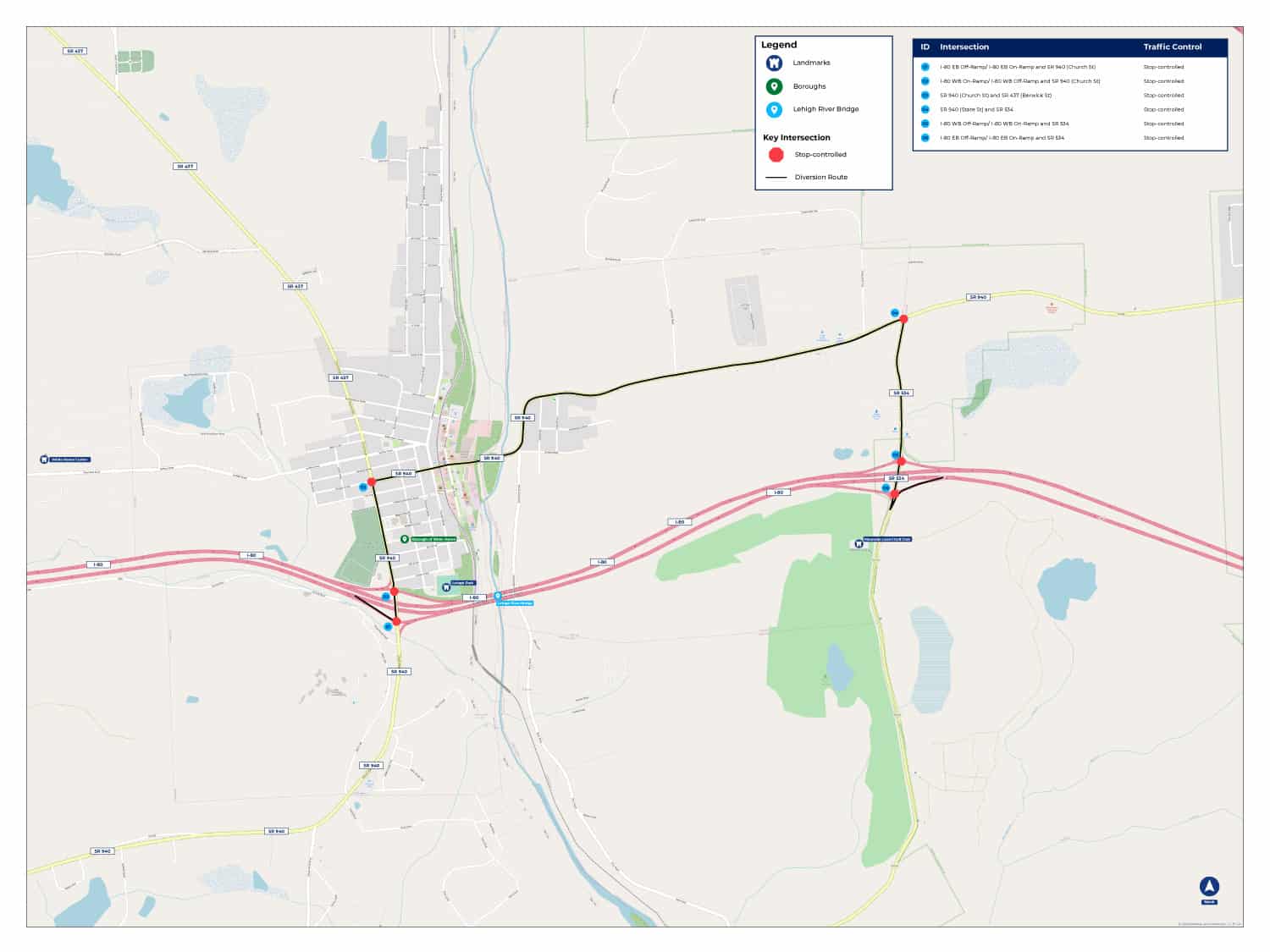 Click to view diversion map larger.
As you can see from the table below, the AM and PM Peak Hour traffic on the bridge will be reduced by approximately 100-120 vehicles per hour, and the primary diversion route will increase by approximately 70-80 vehicles per hour. The remaining diverted traffic will utilize a variety of other routes, but those routes will not be substantially impacted given the amount of traffic predicted to use them.
2023 Peak Traffic Volume
| Route |
Time Period |
Pre-Toll Traffic |
Post-Toll Traffic |
| Primary Diversion Route |
AM Peak Hour |
225 |
305 |
| Primary Diversion Route |
PM Peak Hour |
300 |
370 |
| I-80 Lehigh River Bridges |
AM Peak Hour |
2,080 |
1,980 |
| I-80 Lehigh River Bridges |
PM Peak Hour |
2,800 |
2,680 |
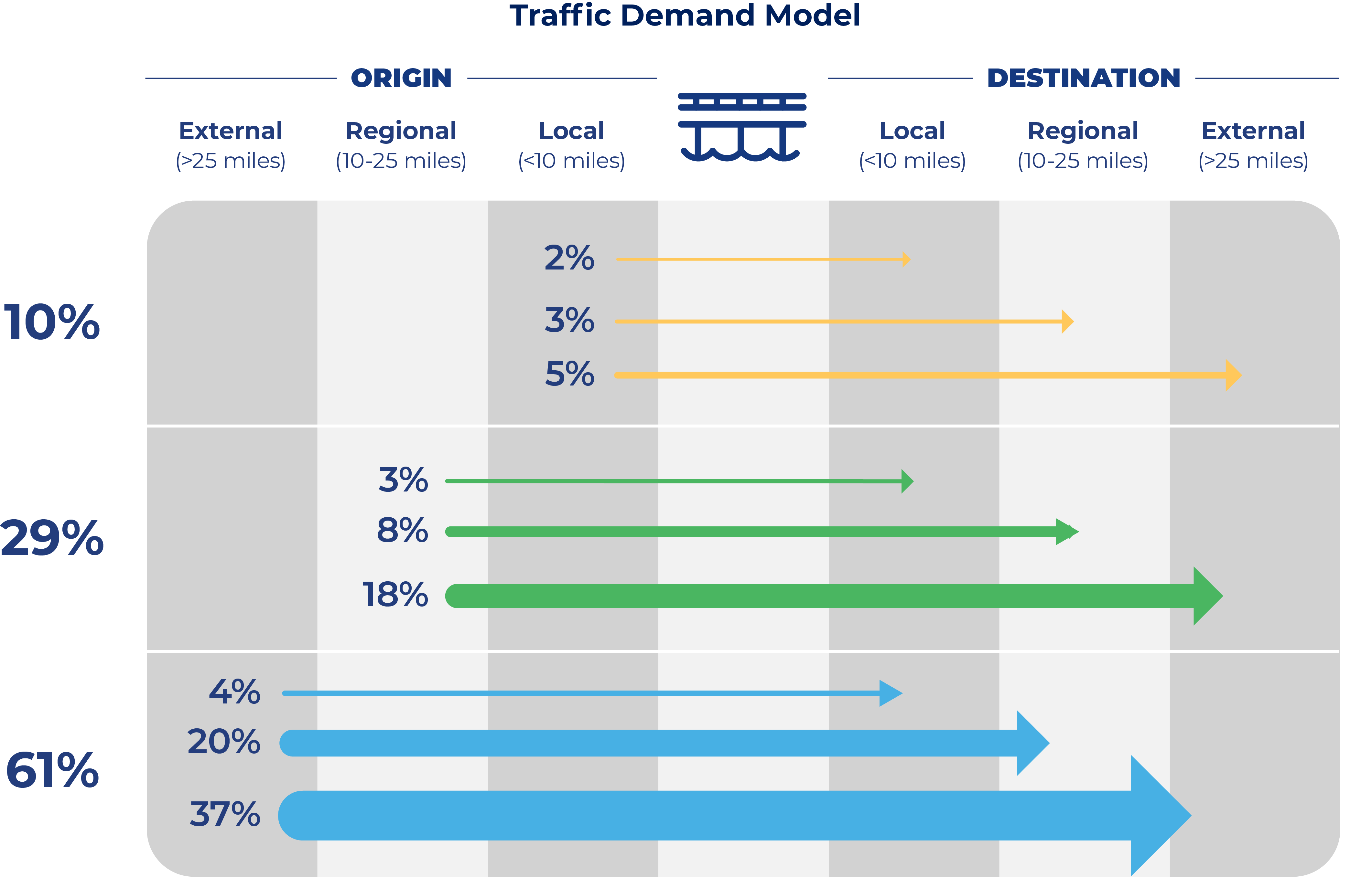
The origin-destination patterns are also taken into account in looking at diversion. The origin-destination criteria is divided into three categories: local (less than 10 miles), regional (10-25 miles) and external (more than 25 miles). As you can see in the graphic below, the majority of the traffic traveling over the bridges originates from external locations and is destined to external locations. Because these trips are typically long-distance trips, this type of traffic is more likely to stay on the interstate and not divert.
When people hear about vehicles diverting from the interstate to avoid a tolled bridge, they often envision what happens when there is a full traffic detour. To distinguish between a diversion and a detour in simple terms, diversions are a choice, detours are mandatory.
Detours are imposed because of construction or an incident on a roadway or bridge and those detours must be followed. In contrast to a detour, diversion from the interstate is a choice that drivers may make to avoid a toll and the diversion traffic is normally a small fraction of the number of vehicles compared to detours, when 100 percent of traffic leaves the interstate.
Traffic Diversion Methodology
Once it was determined how much traffic would divert and the primary route that would be utilized, a comprehensive evaluation of the potential impacts to the diversion route was undertaken. The graphic below highlights the key methodology for the evaluation of the diversion route.
Route Identification
Prioritize routes that add more than 100 vehicles per day
Traffic Projections
No toll vs. tolling scenario comparisons
Route Conditions
Intersections, traffic control, signage, & pavement conditions
Crash Data Summary
Identify crash patterns & crash rates
Capacity Analysis
Depict operational issues & capacity limitations
Roadway Review
Evaluation of lane widths and pavement structure
Alternative Transportation Modes
Transit, bus, bike lanes, etc.
Potential Mitigation Options
Evaluation of options to offset impacts to community
A workshop was conducted with key stakeholders in August 2021 to get feedback on the diversion route analysis and collect additional information on routes drivers might take, and potential impacts from diverting traffic. This feedback was incorporated into the traffic diversion analysis and evaluated to identify improvements PennDOT could consider to mitigate effects on the community caused by toll diversion. The analysis and recommended improvements to off-set effects are shared below.