Market Street Bridge
Overview
The Market Street Bridges, designated as State Route (SR) 3012 in Dauphin County and SR 1010 in Cumberland County, runs over the east and west channel of the Susquehanna River connecting the communities of Harrisburg, Dauphin County, and Wormleysburg Borough/Lemoyne Borough, Cumberland County, Pennsylvania. PennDOT has commenced design work on the Market Street Bridge Project that includes rehabilitation of the bridges. Market Street is a primary commuter route and provides a connection over both the east and west channels of the Susquehanna River to City Island. Construction is anticipated to start as early as 2025 based on current programmed funding.
Existing Bridges – The western bridge is a 16-span adjacent concrete box beam bridge that connects Lemoyne and Wormleysburg to City Island over the west channel of the Susquehanna River. The eastern bridge is a 16-span closed spandrel arch bridge that connects City Island to the City of Harrisburg over the eastern channel of the Susquehanna River. Currently, the eastern bridge provides four 10-foot lanes and two 5-foot 9-inch sidewalks with no shoulders on either side, while the western bridge provides four 10-foot lanes and two 4-foot 7-inch sidewalks with no shoulders on either side.
Both bridges currently carry state Bike Route J. Though bicyclists have access to the roadway, there is no dedicated bike lane or shared lane signs on the roadway notifying motorists to share the road. Bicyclists also use the existing sidewalks.
Sidewalks have deteriorated on the eastern bridge. In addition, metal plates for the hatches used to access the interior of the bridge are located within the existing sidewalks. Many of these hatches are not accessible for interior bridge inspection and damaged hatches cause tripping hazards on the sidewalks. On the western bridge, sidewalk panels exhibit cracking and spalls and the downstream sidewalk is currently closed due to underlying beam conditions.
Project Purpose – The purpose of the project is to maintain safe and efficient multimodal connectivity across the Susquehanna River between Harrisburg and the West Shore communities, as well as access to City Island and its amenities. The eastern bridge is listed on the National Register of Historic Places; therefore, it is a goal of the project to maintain the historic integrity of the bridge.
Project Scope – The scope of work for the bridge improvements includes the rehabilitation of the historic arch and replacement of the deck and upstream sidewalk on the 16-span eastern bridge as well as the construction of a new superstructure (deck and beams) on the 16-span western bridge.
Both bridges will maintain four 10-foot lanes, similar to current conditions. Smoother sidewalk surfaces will be provided on both bridges. While the eastern bridge is expanding the existing upstream sidewalk width by 1-foot, metal hatches will be removed from the sidewalk areas, and the upstream sidewalk will be replaced with a smoother surface. Additionally, a 2-foot upstream shoulder and a 1-foot 9-inch downstream shoulder will be added. For the western bridge, one 7-foot upstream sidewalk along with
2-foot shoulders, both upstream and downstream, will be constructed. These improvements will provide additional space for bicyclists and a buffer area between vehicles and pedestrians on the sidewalk.
The downstream sidewalk on both bridges will be eliminated since the utility bridge will provide a 14-foot wide pathway for bicycle and pedestrian use in lieu of the downstream sidewalk. Additional bicycle signage (Share the Road and Bicycles May Use Full Lane), pavement markings, and shared lane use markings in the right lane in each direction will also be added from the west shore to the east shore. Pavement Markings and Signage will be included at both of the adjacent signalized intersections on the west shore and east shore.
The Lemoyne Bottleneck Project is ongoing to improve bicycle and pedestrian safety on Market Street on the western shore. Coordination will occur between the two projects to ensure improvements connect seamlessly.
Recommended Preferred Alternative – As a result of comments received during the November 2021 to January 2022 public comment period, as well as the June 2022 comment period, PennDOT is recommending to proceed with the design and environmental clearance of both bridges being rehabilitated with the addition of a separate utility bridge that will carry all utilities, as well as allow bicycle and pedestrian access, which provides a crossing that is physically separated from vehicular traffic. This additional utility bridge will reduce the overall construction time by four to five years, as well as serve as an accessible, safe commute for bikes and pedestrians.
Utility Bridge with Bicycle and Pedestrian Access – A separate bridge is proposed to be built downstream that carries all the utilities that are currently under the sidewalks on the Market Street bridges. Utilities include gas transmission lines, multiple fiber optic telecommunications lines, and a sewer line. The utility bridge provides several benefits to the project including:
• Can be constructed without long-term traffic control, i.e. lane reductions or detours.
• Reduces overall construction duration by four to five years because no temporary utility relocations are required.
• Provides a safer commuting experience for bike/ped users who may be apprehensive about the traffic on the Market Street bridge sidewalks.
• Limits temporary outages for all utilities because there will only be one outage for connecting new lines to existing lines.
• Eliminates future traffic disruptions by utility companies working on their facilities on the Market Street bridges.
• Quicker access for emergency services to respond to incidents.
• During construction, provides a viable alternative to work zones for bike/ped safety.
Environmental
The eastern Market Street Bridge, constructed in 1928, is an excellent example of a long-span monumental urban bridge. The crossing where the current bridge stands has historically been the western gateway to the City of Harrisburg. The eastern bridge was listed on the National Register of Historic Places in 1988. The bridge is 16-spans and 1,415 feet in length from Front Street in the City of Harrisburg to City Island. The bridge is a concrete arch bridge with a stone facing. The stone was cut to create the arch shape. The eastern entrance to the Market Street Bridge is notable due to the red
sandstone Doric columns on either side that were taken from the site of the original State Capital. The State Capital burned in 1897. The columns were reused for the entrance to the bridge and have commemorative plaques on all four sides at the base.
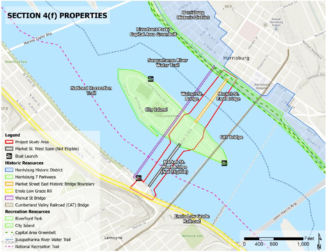
Section 4(f) properties are publicly owned parks, recreational areas, and wildlife/waterfowl refuges; parts of public multi-use properties that provide park/recreational and wildlife/waterfowl refuge; and historic properties (U.S. DOT Act 1966). Within the Market Street Bridge project vicinity, several properties qualify as Section 4(f) resources, such as:
• Harrisburg Historic District (Historic)
• Harrisburg City Parks 7 Parkway Plan (Historic)
• Market Street Bridge East (Historic)
• Pennsylvania RR Enola Low Grade freight/Cumberland Valley RR (Historic)
• River Front Park (Recreation)
• City Island (Recreation)
• Capital Area Greenbelt (Recreation)
• Susquehanna River PA Water Trail/National Recreation Water Trail (Recreation)
These resources will be temporarily used (de minimis use) during construction due to limited access points to the bridges. None will be adversely affected and will be restored once construction is completed.
Land and Water Conservation Funds (LWCF) were used in the development of recreational amenities on City Island. Resources receiving funds through LWCF are afforded protection under the Land and Water Conservation Fund Act and are Section 6(f) resources. Coordination with the Pennsylvania Department of Conservation and Natural Resources and the City of Harrisburg is occurring to determine appropriate mitigation for the temporary use of the island for temporary construction staging areas and access to the causeways. Final approval will be provided by the National Park Service.
Part of this process consists of evaluating the project for compliance with the National Environmental Policy Act (NEPA), which includes coordination with agencies, public involvement, and other outreach activities.
Utilities
Multiple utilities are attached to the existing bridges and are located under both sidewalks. Utilities include telecommunications, gas, sewer, and electric. Permanent relocation of all utilities to a separate utility bridge is planned to reduce construction time and remove access constraints currently present via metal hatches on the existing bridges.
Right of Way
Temporary and permanent right-of-way acquisitions may be needed on the approaches to the bridges on the west and east shores as well as on City Island to allow construction of the proposed bridge rehabilitation. Portions of the parking lots on City Island will be needed for the contractor to stage materials and equipment as well as gain access to river causeways.
Maintenance and Protection of Traffic
During construction, westbound vehicular traffic is proposed to be detoured on both bridges while maintaining one eastbound lane between the west and east shores on the existing bridges. This approach allows for three main phases of construction. If two-way access across either bridge was
required, an additional phase of construction would be added, which could extend the overall construction duration by 1-2 years. The overall phases are:
• Phase 1 – Construct the utility bridge and relocate all utilities from the Market Street Bridges to the new utility bridge. Existing travel lanes will be maintained except for short-term lane closures with flagging to accommodate utility reconnections.
• Phase 2 – Construct the eastbound (downstream) side of the bridges. One eastbound lane will be maintained on the upstream side with all westbound traffic detoured via Harvey Taylor Bridge. Access to City Island will be from the westbound ramp.
• Phase 3 – Construct the westbound (upstream) side of the bridges. One eastbound lane will be maintained on the newly constructed downstream side with all westbound traffic detoured via Harvey Taylor Bridge. Access to City Island will be from the eastbound ramp.
Pedestrian and Bicycle Access: Throughout the entire duration of construction, bike/ped access across the river or to/from City Island will be provided. The utility bridge will be constructed first. Once constructed, it will be used for bikes and pedestrians during the remaining phases of construction on the Market Street Bridges. During short term periods, the utility bridge will require closure while the downstream side of the western Market Street Bridge is being demolished and new beams are lifted in place up and over the utility bridge during Phase 2. At those times, the existing upstream sidewalk will still provide passage as it does today. Bus stops and parking lots on City Island will remain open and accessible during all phases of construction.
Boater Access Under the Bridge: Construction of the bridges will require half-width causeways in each channel for contractor access (half of the eastern and western channels will always be open). An Aids to Navigation Plan will be developed in coordination with the PA Fish and Boat Commission. Boater access will be maintained in areas not occupied by causeways. Access will be maintained in each channel of the river for the duration of construction.
Regional Project Coordination
Several projects, including the Lemoyne Bottleneck Project to improve bicycle and pedestrian safety on Market Street on the western shore, and the I-83 South Bridge over the Susquehanna River Replacement Project are also in the design phase. The Market Street design team will be coordinating with the other design teams during the duration of the Market Street Bridge Project. The timing of construction for each project will continue to be coordinated to determine the most appropriate schedule of construction overall. Project details for other projects will be disseminated by those design teams through the PennDOT District 8 website.
Schedule and Cost
The project is currently in the preliminary design phase, and construction is anticipated to begin as early as 2025. Currently, the estimated construction cost is $113.6 Million.
A digital version of the information will be available for public comment until 11:59 PM Monday, August 7, 2023. An in-person open house will be held on July 12, 2023, from 6 p.m. to 8 p.m., at the Wormelysburg Borough Office, Knisley Hall, and August 1, 2023 from 6 p.m. to 8 p.m., at the Harrisburg City Government Center 10 North 2nd St.