Begin Main Content Area

Content Editor

PennDOT Pathways I-80 North Fork Bridge Online Meeting

I-80 North Fork Bridges Project

This page is best viewed in Chrome, Edge or Firefox.

Virtual Public Meeting

Thank you for joining us to learn more about the I-80 North Fork Bridges Project. We're here to provide information on the project's purpose and need, proposed improvements, noise wall considerations, schedule and funding and to explain how you can stay informed and get involved.

To respect your health and adhere to public safety and social distancing guidelines, we are presenting information on this project through an on-demand virtual public scoping meeting. You can access this meeting anytime between March 1 and March 22, 2021 at your convenience.

We encourage comments on the project. Comments will be accepted through March 22 when the meeting closes. Comments may be submitted via the comment form at the end of this meeting, via email to i80NorthFork@pa.gov, by leaving a message on our hotline at 814-796-5009 or by sending a letter to:

PennDOT Engineering District 10-0
c/o I-80 North Fork Bridges Project
2550 Oakland Avenue
Indiana, PA 15701-3388.

How To Navigate This Meeting


To advance to the next portion of the meeting, scroll down or use the navigation bar at the top of the page to revisit any part of the meeting.

Project Overview

The existing North Fork Bridges were built in 1962 and cross of the North Fork Redbank Creek and Water Plant Road near Brookville. Combined, the bridges currently carry an average of more than 26,000 vehicles each day, approximately 36 percent of which is truck traffic. By the time this project is complete in 2027, these numbers are expected to rise to around 31,000 vehicles per day with 42.5 percent truck traffic.

The study area for the North Fork Bridges Project lies entirely in Jefferson County. The eastern project limit is just east of the Richardsville Road (SR 4005) overpass. The study area includes both the westbound and eastbound bridge structures over the North Fork Redbank Creek and extends westward just beyond where I-80 passes over Jenks Street (SR 4003).

Study Area Map
1 / 10
Existing Eastbound North Fork Bridge
2 / 10
Existing Eastbound North Fork Roadway
3 / 10
Existing Westbound North Fork Bridge
4 / 10
Existing Westbound North Fork Roadway
5 / 10
Existing Eastbound I-80 over Jenks Street (SR 4003) Bridge
6 / 10
Existing Eastbound I-80 over Jenks Street (SR 4003) Roadway
7 / 10
Existing Westbound I-80 over Jenks Street (SR 4003) Bridge
8 / 10
Existing Westbound I-80 over Jenks Street (SR 4003) Roadway
9 / 10
Existing Eastbound Richardsville Road (SR 4005) Bridge
10 / 10
Existing Eastbound Richardsville Road (SR 4005) Roadway

The project includes the replacement and realignment of the North Fork Bridges on I-80, as well as the replacement of the dual I-80 bridges over Jenks Street and the Richardsville Road bridges over I-80. The project also includes the extension of the North Fork Park Culvert, which carries I-80 traffic over the tributary to North Fork Redbank Creek.

During construction, two lanes of traffic will remain open in each direction on I-80.

Purpose & Need

At 59 years old, the North Fork Bridges are nearing the end of their serviceable lifespan. This means that wear and tear is occurring more often, requiring more frequent and more costly repairs.

The purpose of the project is to provide safe, efficient and effective crossings of I-80 over the North Fork Redbank Creek and Water Plant Road that meet the demands of modern interstate traffic.

This project is intended to address the following needs:

The bridge's aging structure

Both bridge structures are approaching the end of their serviceable lifespan. This means that the structures have become susceptible to fatigue-related fractures because of their age and the amount of wear and tear caused by vehicles on the bridges. In the near future, this wear and tear will cause the need for more frequent and costly repairs. The eastbound bridge is in poor condition, and the westbound bridge is in fair condition.

Need for design and safety improvements

The existing roadway system is outdated and does not meet current design standards. Specifically, the curve on the western edge of the eastbound bridge is not suitable for 70-mile-per-hour traffic, and many accidents, nearly twice the state average, have occurred on this segment of I-80.

Proposed Improvements

This project proposes to replace three sets of bridges in the project area:

  • The eastbound and westbound bridges on I-80 over the North Fork Redbank Creek and Water Plant Road.
  • The eastbound and westbound bridges on I-80 over Jenks Street (SR 4003).
  • The eastbound and westbound bridges on Richardsville Road (SR 4005) over I-80.

To address the substandard curvature of the eastbound North Fork bridge, this project includes the realignment of the eastbound bridge to run parallel to the westbound bridge, which will be reconstructed in its existing location. The existing roadway on I-80 eastbound will be abandoned.

In addition, this project will extend the existing arch culvert that carries I-80 traffic over the tributary to North Fork Redbank Creek.

You can view the proposed realignment, the location of the three bridge replacements and the culvert extension in the map below.

Proposed Improvements Map

I-80 North Fork Bridges Project Roadway Plan Sheets


I-80 North Fork - Project Plan Sheet 1
Click here to view larger.

I-80 North Fork - Project Plan Sheet 2
Click here to view larger.

I-80 North Fork - Project Plan Sheet 3
Click here to view larger.

Project Visualizations

We have produced a series of renderings to help you visualize what the proposed North Fork Bridges, I-80 roadway and Richardsville Road (SR 4005) bridge would look like once complete.

1 / 8
Aerial view of the proposed I-80 North Fork Bridges (looking east, Walter Dick Memorial Park to the right)
2 / 8
Proposed I-80 North Fork Bridges (looking south toward Walter Dick Memorial Park)
3 / 8
Proposed I-80 North Fork Bridges (looking east)
4 / 8
Proposed I-80 North Fork Bridges (looking west)
5 / 8
Proposed I-80 North Fork Bridges piers (looking south toward Walter Dick Memorial Park)
6 / 8
Proposed I-80 Eastbound and Westbound roadway (looking east)
7 / 8
Proposed SR 4005 (Richardsville Road) bridge over I-80 (looking east)
8 / 8
Proposed SR 4005 (Richardsville Road) bridge over I-80 (looking west)

In addition, we have prepared the following typical sections to demonstrate how traffic would operate on the North Fork Bridges, the I-80 bridges over Jenks Street (SR 4003), the Richardsville Road (SR 4005) bridge, on I-80 through the project corridor and on Jenks Street (SR 4003) under the I-80 bridges:


I-80 Typical Bridge Sections
Click here to view larger.

I-80 Typical Bridge Sections
Click here to view larger.

I-80 Typical Roadway Sections
Click here to view larger.

Detour Information

The project team does not anticipate any detours on I-80 throughout the duration of construction. I-80 will maintain two lanes of traffic in each direction for the majority of construction. During certain construction activities, such as tie-in work, temporary lane closures may occur, leading to occasional traffic delays during peak hours.

We anticipate detours on both Jenks Street (SR 4003) and Richardsville Road (SR 4005):

Jenks Street (SR 4003) Detour

We anticipate a detour during the replacement of the I-80 bridges over Jenks Street (SR 4003). This 3.1-mile detour route would use SR 0028 (West Main Street), SR 0036 (Allegheny Boulevard) and SR 0322 (US 322; West Main Street). PennDOT will continue to coordinate with the Brookville Area School District throughout the design process. A temporary bus stop will be added south of the I-80 bridges over Jenks Street to transport students in the area to school during construction. Jenks Street is posted at 10 tons, and truck travel along the street is restricted except for local deliveries.

We anticipate that this detour will last for one construction season, or 7 months from April to October.

Richardsville Road (SR 4005) Detour

We anticipate a detour during the replacement of the Richardsville Road (SR 4005) bridges over I-80. The 5.3-mile detour route would use SR 0322 (US 322, East Main Street), SR 0028 and T-430 (Butler Cemetery Road) and would be approximately 5.3 miles overall. T-430 (Butler Cemetery Road) is posted at 10 tons and will be improved as part of the project. We will coordinate with Pine Creek Township to use Butler Cemetery Road as part of the official detour route.

We anticipate that this detour will last for one construction season, or 7 months from April to October. Toward the end of the project, the existing Richardsville Road (SR 4005) bridges over I-80 will be demolished and removed, requiring an additional 3-month-long detour.

Noise Wall Consideration

Using a Traffic Noise Model approved by the Federal Highway Administration (FHWA), we conducted a noise study in the project area to predict what sound levels would be in a worst-case scenario at project completion. This study included all residences, schools, business, parks, etc. in the project area.

The study was used to determine if noise mitigation tactics, in this case, noise walls, could feasibly and reasonably reduce noise impacts. In this context, a noise impact is defined by any sound level that exceeds 66 decibels on the human perception scale (dBA) or is a 10dBA increase over existing conditions.

The study results determined that noise walls would be feasible and reasonable in two locations near the eastern terminus of the project area, as shown on the map below.

Noise Wall Public Involvement Process

Noise Wall Locations
Click here to view larger.

As part of the public involvement process, we will contact the owners and renters of sites that would benefit from the noise wall to vote on its construction. If more than 50 percent of the votes are in favor of constructing a noise wall, it will be advanced into the Final Design phase of the project. If approved, the owners and renters would vote to determine the texture and color of the residential side of the wall, and PennDOT would determine the texture and color of its interstate side.

Local Impacts

Brookville Area High School will experience minimal impacts during construction. Some grading work along Jenks Street (SR 4003) will require a small right-of-way acquisition near the sidewalk adjacent to the football field.

We do not anticipate any impacts to the Brookville Cemetery.

Because of the realignment of the eastbound North Fork bridge, Walter Dick Memorial Park will be both temporarily and permanently impacted by construction. However, the project team does not anticipate any impacts to the footbridges.

The park will remain open for recreational activities during construction, though park access may be temporarily limited during certain activities, such as bridge demolition or girder installation. When known, information about temporary park restrictions will be posted to the I-80 North Fork Bridges Project website and the Brookville Borough website.

Environmental Study

To comply with the National Environmental Policy Act (NEPA), the I-80 North Fork Bridges Project is being advanced as a Categorical Exclusion (CE). During the environmental review, we will assess impacts to natural, social, economic and cultural resources in the project area.

Funding

The I-80 North Fork Bridges Project is proposed to be funded in part by a bridge toll.

PennDOT currently faces an 8.1-billion-dollar gap in annual highway and bridge funding. This means we are not generating enough funds to properly maintain, restore and expand our transportation network. We are taking action to find reliable sources of funding through the PennDOT Pathways program.

As the mobility needs of Pennsylvania have grown, the amount of funding required to support our highway and bridge network has continued to increase. Much of our current funding comes from gas taxes and driver and vehicle fees. While this model worked well in the past, circumstances today have made it unsustainable. With PennDOT Pathways, we are looking for reliable, future-focused funding solutions that will meet our growing needs while serving our communities and all Pennsylvanians for generations to come.

For more information about PennDOT Pathways, visit www.penndot.gov/funding.

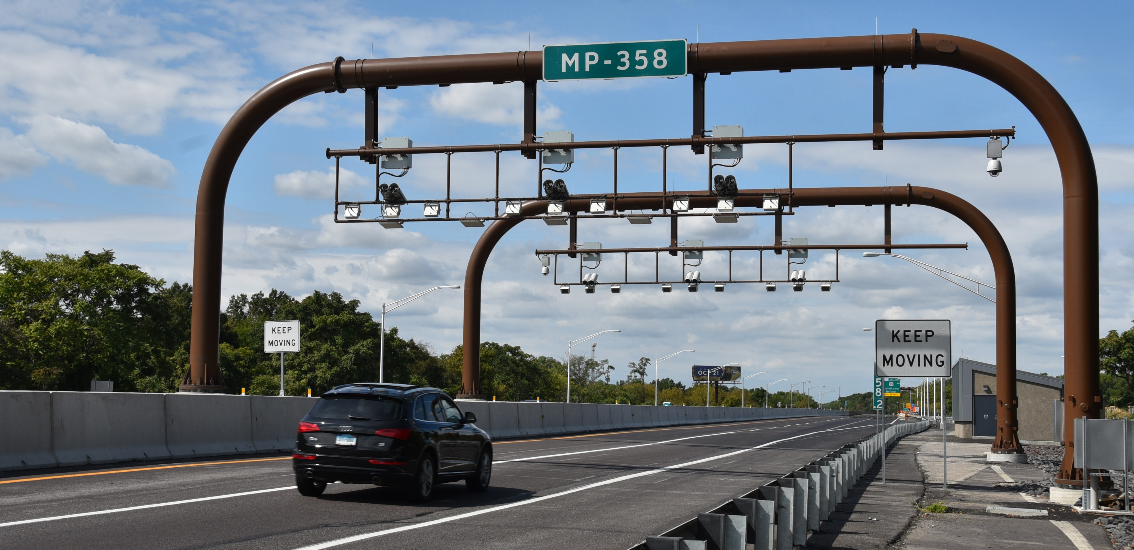
One of the funding solutions we are studying is the implementation of bridge tolls on major bridge projects across the state. The I-80 North Fork Bridges Project is one of several projects being evaluated as a candidate for bridge tolling as a part of the PennDOT Pathways Major Bridge Public-Private Partnership (P3) Initiative. You can learn more about the program and initiative at the link above.

A bridge toll is a fee that drivers pay when using a specific bridge, often by using a service like E-ZPass. The funds received from this toll would go right back to the I-80 North Fork Bridges Project to pay for its construction, maintenance and operation.

As part of the environmental review process, we are evaluating the effect bridge tolling may have on local communities from traffic diverting onto other roads to avoid paying the toll. Part of this analysis will look at potential impacts to low-income and minority populations. We will continue to work closely with you and your communities as the project advances. The project team will host an additional public meeting later this year to present the findings of these environmental studies and the Diversion Route Analysis in the region.

Project Schedule

The next step for the project is to complete the environmental review process, which is expected to happen later this year. The project is currently in the design phase and will continue to work toward final design through 2023. Potential tolling on the project would start in mid- to late-2023, and construction is anticipated to begin in 2024.