This project is one of nine that are being evaluated as a candidate for bridge tolling as a part of the Major Bridge P3 Initiative. More information on bridge tolling and the PennDOT Pathways program can be found in the Bridge Tolling section of this Open House below. There has been an update to PennDOT's planned tolling approach for the I-78 Lenhartsville Project. Following community input and continued project analysis, PennDOT will pursue only westbound tolling at this bridge.
PennDOT, in coordination with FHWA, is preparing EAs for the Major Bridge Public-Private Partnership (P3) Initiative candidate bridges in accordance with NEPA. These EAs examine the significance of potential impacts to natural, social, economic, and cultural resources from the alternative(s) under consideration. The results of the EA's environmental analysis will determine whether an Environmental Impact Statement needs to be prepared, or whether a Finding of No Significant Impact can be issued.
The project's original CE was completed in November 2019 and a plan display and public officials meeting was held on October 28, 2019 at the Greenwich Township Building. At that time, the project included only the bridge and roadway improvements, the tolling concept had not yet been introduced. There was no public controversy identified as a part of that public outreach process. Since the introduction of the tolling concept, the project team previously hosted public meetings on this project, online and in person in November and December 2021. Links to information presented during those meetings are available on the project website at www.penndot.pa.gov/i78Lenhartsville.
The project is currently in preliminary design, and construction is anticipated to begin in 2024.
Project Design
As already presented and approved in the original CE evaluation of 2019, PennDOT proposes a total replacement of the I-78 Lenhartsville Bridge with a widened structure (to accommodate the addition of auxiliary lanes in each direction and full inside and outside shoulders which are currently substandard), roadway improvements along both bridge approaches on I-78, and ramp reconstruction at Exit 35 Interchange to accommodate the widening and addition of acceleration and deceleration lanes.
You can see a plan sheet of the project design below.
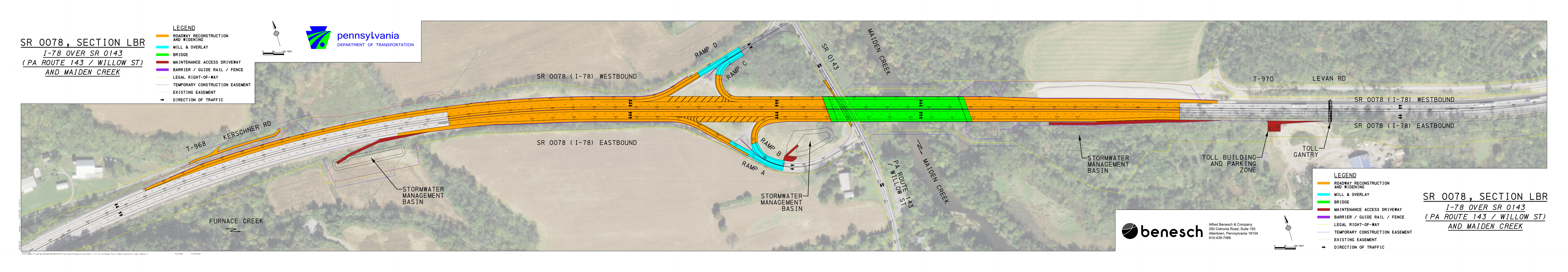 Click to view design plan sheet larger.
The bridge will be reconstructed utilizing staged construction. It is anticipated that approximately seven stages will be required to facilitate construction while maintaining two travel lanes along I-78 in each direction. The stages will shift the travel lanes away from work areas to allow the contractor to complete the work. Temporary barrier will separate traffic from the work areas. Long-term closures of any I-78 or SR 143 travel lane is prohibited. However, one 15-minute total stoppage will be permitted every hour during off-peak hours. Single lane closures along I-78 will also be permitted during off-peak hours. Long-term I-78 and SR 143 interchange ramp closures are necessary to complete the interchange reconstruction. Only half of the interchange will be permitted to be closed at one time. It is anticipated the ramp detours will be in place for no longer than two weeks for each detour. No full detour will be needed for the reconstruction of the bridge.
Bridge Tolling
Funding
The estimated cost of construction for the I-78 Lenhartsville Bridge Replacement Project is between $50 and $60 million.
PennDOT Pathways is a program to identify and implement alternative funding solutions for Pennsylvania's transportation system. As Pennsylvania's mobility needs have grown, the amount of funding required to support our transportation system has continued to increase. Much of our current funding comes from gas taxes and driver and vehicle fees. While this model worked well in the past, circumstances today have made it unsustainable. With PennDOT Pathways, we're looking for reliable, future-focused funding solutions that will meet our growing needs while serving our communities and all Pennsylvanians for generations to come.
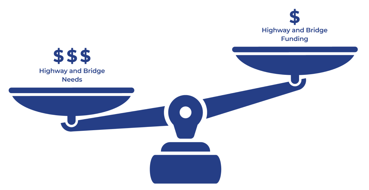
PennDOT currently faces an $8.1 billion gap in highway and bridge funding. This means we aren't generating enough funds to properly maintain, restore and expand our transportation system. PennDOT is taking action to find reliable sources of funding through the PennDOT Pathways program.
For more information about PennDOT Pathways, visit www.penndot.pa.gov/funding.
One of the funding solutions identified in the Planning and Environmental Linkages (PEL) Study was the implementation of bridge tolls on major bridge projects across the state. The I-78 Lenhartsville Bridge Replacement Project is one of several projects being evaluated as a candidate for bridge tolling as a part of the PennDOT Pathways Major Bridge P3 Initiative. You can learn more about the program and initiative at the link above.
A bridge toll is a fee that drivers pay when using a specific bridge, often by using a service like E-ZPass. The funds received from the bridge toll would go back to the I-78 Lenhartsville Bridge to pay for its construction, maintenance and operation.
Toll Implementation
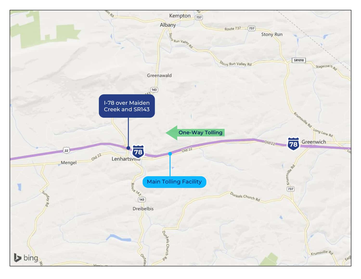
There has been an update to PennDOT's planned tolling approach for the I-78 Lenhartsville Project. Following community input and continued project analysis, PennDOT will pursue only westbound tolling at this bridge.
To implement the toll with All-Electronic Tolling (such as E-ZPass or toll-by-plate), a tolling facility (gantry, building and utilities) will be constructed approximately 1,700 feet east of the new bridge and will require the installation of small driveway/parking area along the eastbound shoulder for maintenance pull-out and access. The tolling facility will not require drivers to stop to pay a toll when using the bridge but will record vehicles as they pass under the gantry sensor. A map of the toll gantry location is below.
In addition, signs will be placed about 1 mile prior to the tolling facility in the westbound direction to inform drivers about the toll bridge, as well as at the nearest interchanges and their respective local roadway network (i.e., Exit 35 to SR 143/Lenhartsville and Exit 40 to SR 737/Krumsville/Kutztown).
PennDOT has established that tolls on the candidate bridges, including the I-78 Lenhartsville Bridge, would be in the range of $1-$2 for cars using E-ZPass and higher for toll-by-plate and for medium or heavy trucks. Exact tolling amounts will be determined once design plans are finalized so the toll would generate enough revenue for the bridge's replacement, operations, and maintenance for a period of approximately 30 years. At the end of the 30-year term for the Public-Private Partnership (P3), the tolling facility would be removed.
Qualifying emergency vehicles would be permitted to use MBP3 bridges at no cost, following the Pennsylvania Turnpike Policy (PDF).
It is expected that toll collection on the bridge would begin between 2023 and 2025.
Environmental Studies
Environmental Assessment
An EA is a document that examines the significance of potential impacts to natural, social, economic and cultural resources from the alternative(s) under consideration. The EA for the I-78 Lenhartsville Bridge Replacement Project was prepared to address the requirements of NEPA, which requires federal agencies to assess the environmental effects of their proposed actions prior to making decisions.
The results of the EA will determine whether an Environmental Impact Statement would be prepared, or a Finding of No Significant Impacts would be issued.

Section 106 (Cultural Resources)
Section 106 of the National Historic Preservation Act requires identification of, and assessment of effects on, historic properties and archaeological sites listed on, or eligible for listing on, the National Register of Historic Places (NRHP). Consultation with persons interested in the historic and archaeological properties/sites is integral to the Section 106 process and the project's public involvement. The Section 106 process includes identifying an area of potential effect (APE) for the project, and inviting property owners within that APE, as well as historical societies and others to participate in the Section 106 process as "Consulting Parties." Separate APEs are established for the archaeological investigations and for above-ground historical properties.
Several historic properties were identified along the I-78 corridor, including the Lenhart Farm, the Maiden Creek Charcoal Furnace and the Hein Farm which are all listed resources in the National Register of Historic Places (NRHP). However, it was determined that the proposed project will completely avoid the properties and thus have no adverse effect on such historic resources.
A small portion of the Grims Mill Farmstead will be acquired for the construction of a stormwater basin; but the property was determined not eligible to the NRHP. Archaeological investigations were completed on the Grims Mill Farmstead property during final design, and it was confirmed there will be no impacts to archaeological resources. It was confirmed a Berks County Conservancy conservation easement exists on this property and a stormwater basin will be located on this property.

Wetland and Waterways Impacts and Mitigation
Wetland and waterway impacts were studied as a part of the Categorical Exclusion environmental studies for the project. The following impacts and mitigation were identified.
| Streams, Rivers & Waterways |
Presence |
Impacts |
| Intermittent (Streams only) |
Present |
Yes |
| Perennial |
Present |
Yes |
| Wild Trout Streams |
Not Present |
No |
| Stocked Trout Streams |
Present |
Yes |
| Federal Wild & Scenic Rivers & Streams |
Not Present |
No |
| State Scenic Rivers & Streams |
Not Present |
No |
| Coast Guard Navigable Waterways |
Not Present |
No |
| Pennsylvania Fish & Boat Commission Water Trail |
Not Present |
No |
| Recreational Boating Waterway |
Present |
Yes |
Maiden Creek and its tributaries, the unnamed tributary to Furnace Creek, and other channels were identified in the immediate project area. These streams were identified by PA DEP's Chapter 93 Water Quality Standards as having water uses protected for Trout Stocked Fishes and Migratory Fishes. 595 linear feet of streams would be impacted due to the permanent widening of the bridge and culvert extensions. There will also be 311 linear feet of temporary stream impacts during construction. Impacts of construction will not affect the navigability of the stream after construction for recreational boaters.
Stream restoration to Channel 2 will be completed to mitigate temporary and permanent impacts that will occur during construction.
Maiden Creek is designated as a stocked trout stream, therefore, construction within the stream will be prohibited from March 1 to June 15.
To address impacts to recreational boaters, the contractor will post warning signs at the construction site (one facing upstream and one facing downstream). Both signs will be placed within 200 feet of the bridge. These signs will warn boaters of the construction site and will be clearly visible. There will be approximately five two- to three-day periods in which it will be unsafe for boaters to pass through the project area and travel will be restricted — during the 1st and 2nd superstructure demolition stage, the demolition of the existing piers stage, and during the 1st and 2nd beam erection stage. The contractor will be required to warn boaters that travel is not permitted under the bridge through the additional "Warning Boaters Keep Out" signage. These signs will be in place during specific bridge demolition and construction activities in which boaters are required to portage.
| Wetlands |
Presence |
Impacts |
| Open Water |
Not Present |
No |
| Vegetated Emergent |
Present |
Yes |
| Vegetated Scrub Shrub |
Present |
Yes |
| Vegetated Forested |
Present |
Yes |
| Exceptional Value |
Not Present |
No |
There will be permanent impacts to three wetland areas as a result of the placement of fill and pier locations. The total acreage of these impacts is 0.043 acres. There will also be 0.507 acres of temporary wetland impacts during construction for access and staging.
To mitigate impacts to wetland areas, orange protective fencing will be placed at the limits of work for wetland areas and some areas will require temporary wooden matting during construction activities to avoid permanent impacts.

Threatened and Endangered Plants and Animals
In studies of threatened and endangered plants and animals within the project area, the Eastern red belly turtle was identified. The following measures will be put in place to avoid impacts to the Eastern red belly turtle.
- No construction activities should be conducted in the water during the overwintering period. All in-stream construction activities should take place between May 1 and October 31 to allow turtles to avoid the project area while they are active
- A Super Silt Fence barrier should be placed around the perimeter of the proposed area of disturbance to prevent turtles from accessing active work zones. This fence should be installed during the inactive period of the red belly turtle (November 1 to April 30) so that turtles do not get trapped in the work zone.
- Prior to the start of construction, potential basking habitat features (e.g., downed trees, rock piles, debris piles) should be removed from the construction area during the turtle’s active period (May 1 to October 31). Removal of the basking sites prior to construction should serve to discourage turtles from using the project area for foraging or hibernating and allow them time to find alternative habitats. Basking features should be replaced where feasible once the project has been completed.
- If any turtles are found within the work area, photos will be taken to document the animals and they will be moved to a safe location outside the work area. PFBC will be notified immediately.
Traffic Diversion
Traffic Diversion Analysis
Traffic diversion analysis comprises two distinct steps. The first is the development of the traffic model to predict how much traffic will divert off the interstate when a toll is imposed and what route that traffic will take. The second step is evaluating and analyzing the diversion routes identified to determine the impact of the diverted traffic on that route and to identify improvements to mitigate those impacts.
A detailed traffic demand model was used to identify diversion routes. The existing statewide demand model that was employed is based on assumptions involving the transportation system, regional demographics and traveler characteristics. These assumptions were then combined using data from traffic counts (including the share of truck traffic), recorded travel speeds and origin and destination patterns, along with regional travel demand models. The model is then run under various parameters to predict the amount of traffic that will be diverted off the interstate and more importantly, where that traffic will go.
If a toll is placed on the westbound I-78 Lenhartsville Bridge, an estimated 4% of daily traffic is expected to choose to divert off the interstate to avoid paying the toll, based on the results of the detailed traffic model. The model was also used to analyze what routes they would predominantly take. Diverting traffic would primarily be passenger vehicles and small trucks.
So where does the majority of the diverting traffic go? The primary diversion route identified for the Lenhartsville Project is Old Route 22. This route is shown on the map below. You can click on the map to enlarge it.
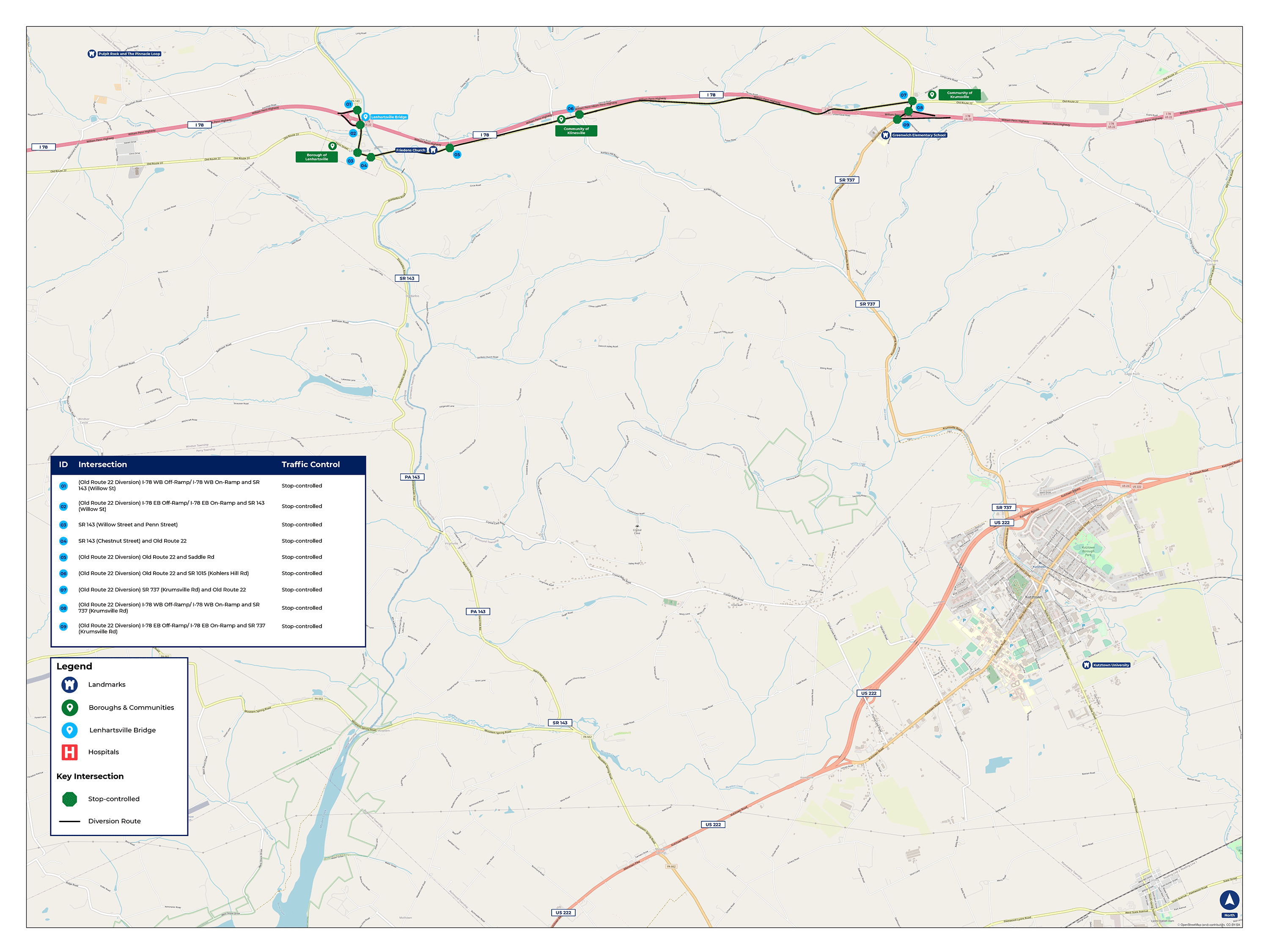 Click to view diversion map larger.
As you can see from the table below, the AM and PM Peak Hour traffic on the bridge will be reduced by approximately 160 to 200 vehicles per hour, and the primary diversion route will increase by approximately 100 to 150 vehicles per hour. The remaining diverted traffic will utilize a variety of other routes, but those routes will not be impacted significantly given the amount of traffic predicted to use them.
Peak Hour Traffic Volume Table
| Route |
Time of Day |
Pre-Toll Traffic |
Post-Toll Traffic |
| Primary Diversion Route |
AM Peak Hour |
140 |
240 |
| Primary Diversion Route |
PM Peak Hour |
240 |
390 |
| I-78 Lenhartsville Bridge |
AM Peak Hour |
4,210 |
4,050 |
| I-78 Lenhartsville Bridge |
PM Peak Hour |
4,920 |
4,720 |
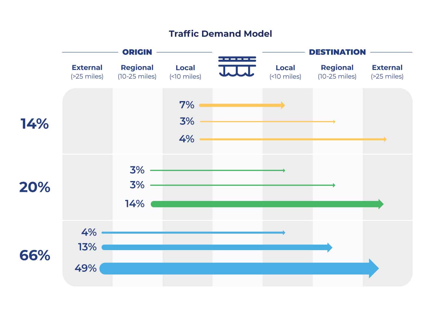
The origin-destination patterns are also taken into account in looking at diversion. The origin-destination criteria is divided into three categories, local (less than 10 miles), regional (10-25 miles) and external (more than 25 miles). As you can see in the graphic below, the majority of the traffic traveling over the bridge originates from external locations and is destined to external locations. Because these trips are typically long distance trips, this type of traffic is more likely to stay on the mainline and not divert. The percentage of local traffic is more minimal and more aligned with the percentage the model predicted would divert from the interstate.
When people hear about vehicles diverting from the interstate to avoid a tolled bridge, they often envision what happens when there is a full traffic detour. To distinguish between a diversion and a detour in simple terms, diversions are a choice, detours are mandatory.
Detours are imposed because of construction or an incident on a roadway or bridge and those detours must be followed. In contrast to a detour, diversion from the interstate is a choice that drivers may make to avoid a toll and the diversion traffic is normally a small fraction of the number of vehicles compared to detours, when 100 percent of traffic leaves the interstate.
Traffic Diversion Methodology
Once it was determined how much traffic would divert and the primary route that would be utilized, a comprehensive evaluation of the impacts to the diversion route was undertaken. The graphic below highlights the key methodology for the evaluation of the diversion route.
Route Identification
Prioritize routes that add more than 100 vehicles per day
Traffic Projections
No toll vs. tolling scenario comparisons
Route Conditions
Intersections, traffic control, signage, & pavement conditions
Crash Data Summary
Identify crash patterns & crash rates
Capacity Analysis
Depict operational issues & capacity limitations
Roadway Review
Evaluation of lane widths and pavement structure
Alternative Transportation Modes
Transit, bus, bike lanes, etc.
Potential Mitigation Options
Evaluation of options to offset impacts to community
A workshop was conducted with key stakeholders in August 2021 to discuss the diversion route analysis, collect information on additional routes drivers might take and potential impacts from diverting traffic. This feedback was incorporated into the traffic diversion analysis and evaluated to identify potential ways PennDOT could mitigate impacts on the community caused by toll diversion. The analysis and recommended improvements to off-set effects are shared below.