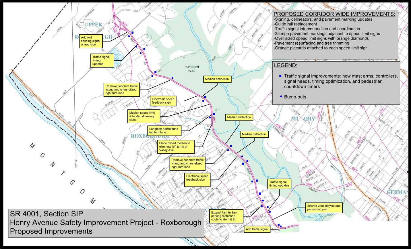
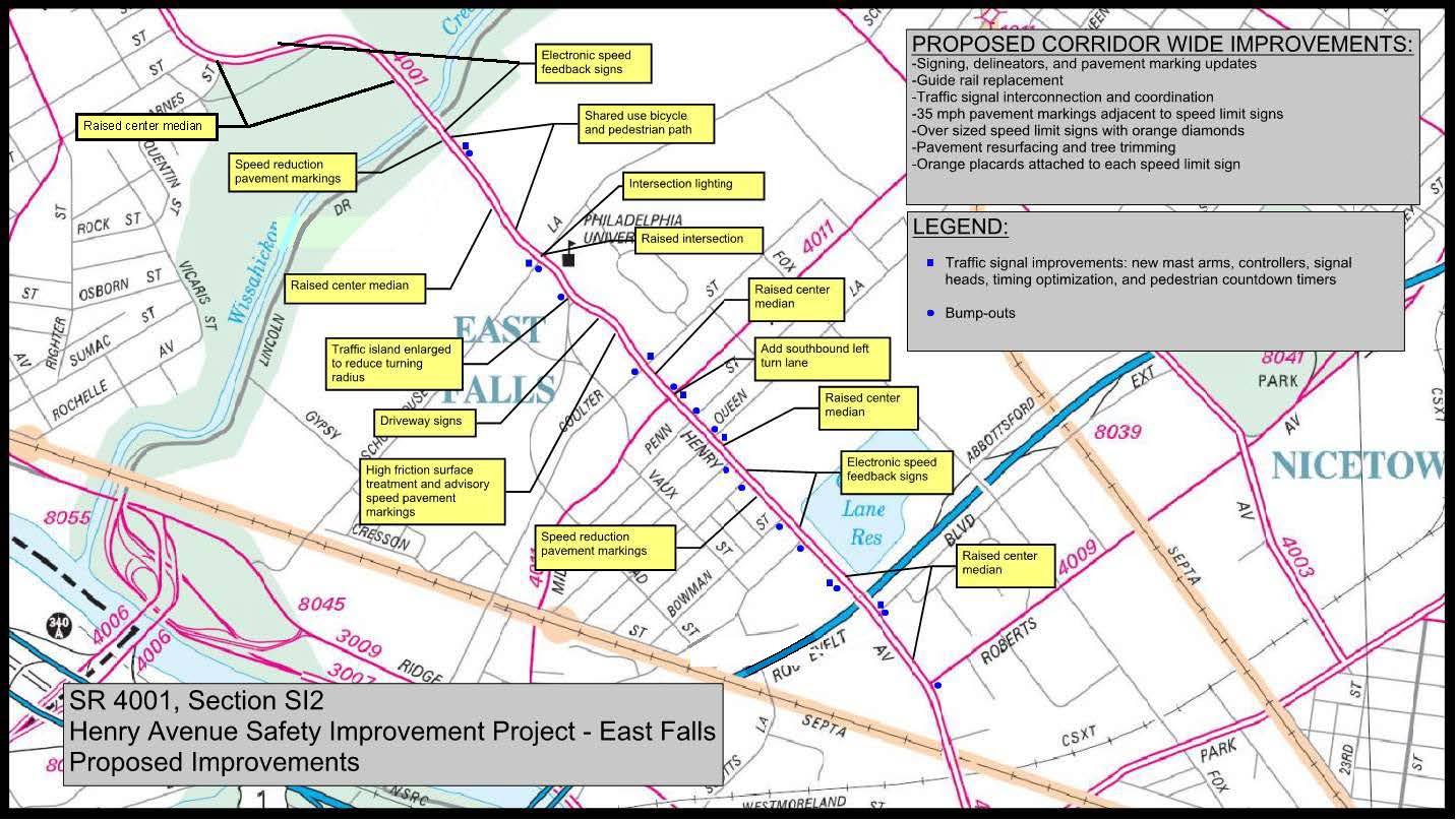
Project Overview
The project involves 4.7 miles of safety improvements along Henry Avenue (State Route 4001) through the communities of Roxborough and East Falls in the City of Philadelphia. The project limits extend along Henry Avenue from Port Royal Avenue to Roberts Avenue. The project is divided into two sections, with construction beginning on the Roxborough section in spring 2021.
The existing road is a four-to-six lane facility adjacent to and traversing through the neighborhoods of Roxborough and East Falls, single-family residences, apartment complexes, businesses, Jefferson University, and the Fairmount Park recreational area. Sections of the road have bicycle lanes, sidewalk, on-street parking, and bus stops. There are 21 signalized intersections and several unsignalized crossings within the project corridor. The project area encompasses environmental resources such as the Wissahickon Creek, Fairmount Park and some properties of historic interest. The existing posted speed limit is 35 mph.
Roxborough Section:
Accordion [2]
Expand AllClick here for a more accessible versionThe proposed safety improvements on Henry Avenue will take place within the Roxborough community of Philadelphia between Barnes Street and Port Royal Avenue in Philadelphia. Construction began in spring 2021 and is scheduled to finish in early 2023.
- Upgrade traffic signals at: Hermit Street; Roxborough Avenue; Monastery Avenue; Dupont Street; Gates Street; Livezey Lane; Cinnaminson Street; Wigard Avenue; Wise Mill Road; Summit Avenue; and Port Royal Avenue. Traffic signal improvements include new mast arms, controllers, and signal heads; timing optimization; and the addition of pedestrian countdown timers. Plan includes reconstructing curb ramps if they were not previously updated by the city.
- Update traffic signal timing at Walnut Lane and Henry on the Park.
- Add a traffic signal at the intersection of Barnes Street and Henry Avenue.
- Update signing and pavement markings along the entire corridor, from just south of the Henry Avenue/Barnes Street intersection to the Henry Avenue/Port Royal Avenue intersection.
- Mill and resurface the entire corridor to match existing grades and cross slopes.
- Replace existing guide rail and end treatments. Where warranted, propose to install painted, galvanized steel guide rail.
- Extend the southbound restricted parking lane (7 a.m. to 9 a.m.) between Monastery Avenue and Walnut Lane south to Hermit Street.
- Install bump-outs, sidewalk and ADA curb ramps at the following intersections: Hermit Street; Walnut Lane; Wendover Street; Jamestown Street; Rector Street; Monastery Avenue; Dupont Street; Leverington Avenue; Gates Street; Livezey Lane; Cinnaminson Street; Wises Mill Road; Henry on the Park Apartment Complex Driveway; Summit Avenue; Port Royal Avenue.
- Eliminate the channelized right turn lanes at the Gates Street and Wigard Avenue intersections by extending the curb radius into the intersection and eliminate the raised concrete island.
- Add a raised concrete median at Valley Avenue to eliminate left turns entering and exiting Valley Avenue.
- Lengthen the northbound left turn lane at Livezey Lane to account for the additional left turns due to adding the median at Valley Avenue.
- Add a raised concrete median from the Wissahickon Creek bridge to Barnes Street.
- Construct a shared-use bicycle and pedestrian path along the east side of Henry Avenue between Barnes Street and Walnut Lane.
- Widen the median to deflect travel lanes onto the shoulder is proposed south of Barnes Street, south of Hermitage Street, north of Gates Street, and north of Cinnaminson Street.
- Interconnect and coordinate traffic signals.
- Add 35 mph pavement markings adjacent to speed limit signs.
- Install oversized speed limit signs with orange diamonds.
- Place electronic speed feedback signs south of Barnes Street, north of Leverington Avenue, and north of Cinnaminson.
- Place speed limit signs on the median side of the road with 35 mph pavement markings south of Cinnaminson Street. Place hidden driveway signs within this section of Henry Avenue.
- Install a red flashing signal ahead sign north of the Port Royal intersection.
- Perform pavement base replacement improvements at specific locations.
East Falls Section:
Accordion [1]
Expand AllClick here for a more accessible versionThe proposed safety improvements on Henry Avenue will take place within the East Falls community of Philadelphia from just south of the Roberts Avenue intersection to Barnes Street. Construction began in fall 2021 and is scheduled to finish in late 2023.
- Upgrade traffic signals at: Abbotsford Avenue; the Medical College Driveway; Queen Lane; Midvale Avenue; Coulter Street; Schoolhouse Lane; and the Jefferson University driveway. Traffic signal improvements include new mast arms, controllers, and signal heads; timing optimization; and the addition of pedestrian countdown timers. The plan includes new curb ramps if they were not previously updated by the city.
- Add vegetative raised center medians south of Abbotsford Avenue, south of the Medical College Driveway, north of Schoolhouse Lane, and from the Wissahickon Creek Bridge to just south of Barnes Street.
- Add concrete raised center medians at the Medical College driveway, Queen Lane, and Coulter Street.
- Add bump-outs, sidewalk and ADA ramps at the following intersections: Roberts Avenue; Abbotsford Avenue; Medical College driveway; Indian Queen Lane; Bowman Street; Ainslie Street; Tilden Street; Queen Lane; Penn Street; Midvale Avenue; Coulter Street; Warden Drive; Schoolhouse Lane; and the Jefferson University driveway.
- Roadway lighting is proposed at the Schoolhouse Lane intersection.
- A shared-use bicycle and pedestrian path is proposed along the east side of Henry Avenue from Schoolhouse Lane to Walnut Lane.
- Place a high-friction surface treatment on the curves north of Coulter Street and north of the Wissahickon Creek Bridge. Also proposed are advisory speed pavement markings for these curves.
- Speed reduction pavement markings are proposed south of Ainslie Street and north of the Jefferson University driveway.
- A median deflection is proposed south of Abbotsford Avenue.
- Place electronic speed feedback signs south of Bowman Street, south of Tilden Street, north of the Jefferson University driveway, and south of Barnes Street.
- Update signs, delineators and pavement markings to meet current standards.
- Attach orange placards to each speed limit sign and add 35 mph pavement markings to travel lanes adjacent to each of these signs.
- Place driveway signs between Coulter Street and Warden Drive.
- Incorporate pavement resurfacing and tree trimming along the entire corridor.
- Update guide rail to meet current standards.
- Enlarge the traffic island at Warden Drive to reduce the turning radius for vehicles traveling south on Henry Avenue and turning right onto Warden Drive.
- Interconnect and coordinate traffic signals.
- Add a southbound left turn lane on Henry Avenue at its intersection with Midvale Avenue.
- Provide a raised intersection at Schoolhouse Lane.
Traffic Impact
PennDOT will maintain traffic on Henry Avenue during construction utilizing long-term lane shifts and short-term operations with single- lane closures.
Motorists can anticipate utility impacts at intersections where traffic signal poles and mast arms are being replaced or where drainage facilities are added.