This project is one of nine that are being evaluated as a candidate for bridge tolling as part of the Major Bridge Public- Private Partnership (P3) Initiative. More information on bridge tolling and the PennDOT Pathways program can be found in the Bridge Tolling section of this Open House below.
PennDOT, in coordination with FHWA, is preparing EAs for the Major Bridge P3 Initiative candidate bridges in accordance with NEPA. These EAs examine the significance of potential impacts to natural, social, economic and cultural resources from the alternative(s) under consideration. The results of the EAs' environmental analyses will determine whether an Environmental Impact Statement needs to be prepared, or whether a Finding of No Significant Impact can be issued.
The project team hosted a public meeting on the project, both in person and virtually, in November and December 2021.
The project is currently in preliminary design.
Project Design
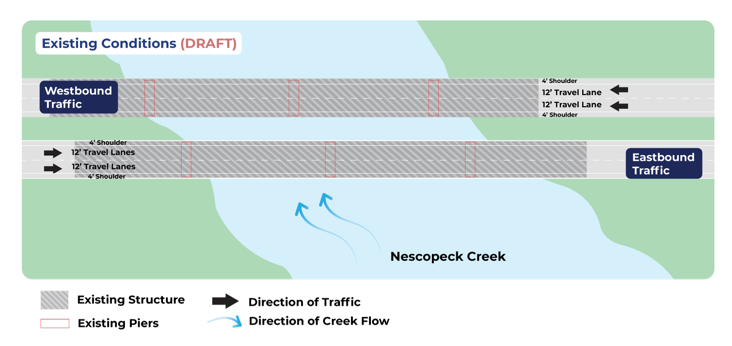
The existing structures are 507-foot long, four-span continuous welded steel girder bridges on concrete abutments and hammerhead piers built in 1965. Each bridge carries two lanes of traffic over Nescopeck Creek.
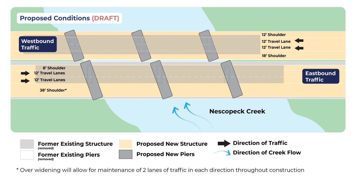
The existing structures are proposed to be replaced with four-span continuous composite prestressed concrete bulb-tee beam bridges with reinforced concrete integral abutments and wingwalls, and reinforced concrete multi-column pier bents on spread footings. The proposed bridges will be widened to accommodate traffic control and future bridge maintenance projects but will only be striped for two lanes. The structures are proposed to be on the same alignment as the existing ones.
Phased construction will be implemented to maintain two lanes of traffic in each direction during construction. No detour of I-80 will be needed for the reconstruction of the bridge. A temporary local detour of the adjacent SR 3016 (Tank Road) will be required to accommodate the widening of I-80 EB.
You can see a plan sheet of the project design, as well as a typical section, below.
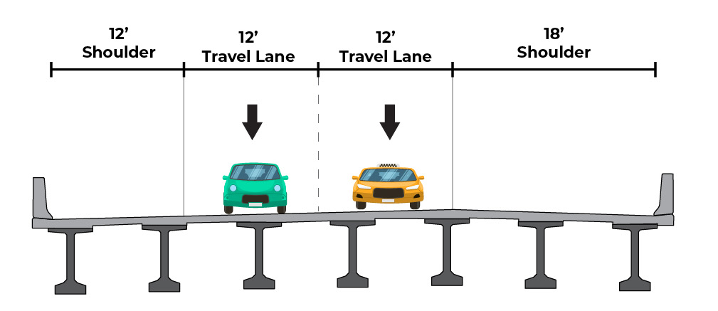
Typical Section
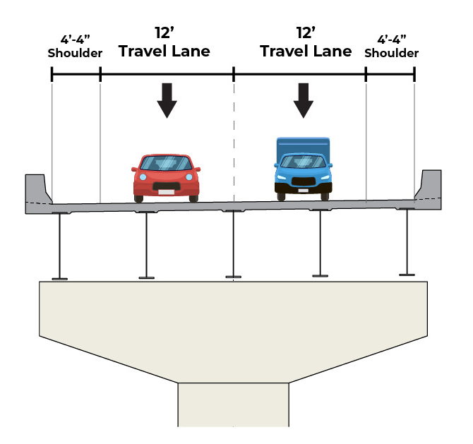 Existing Westbound Typical Section (DRAFT)
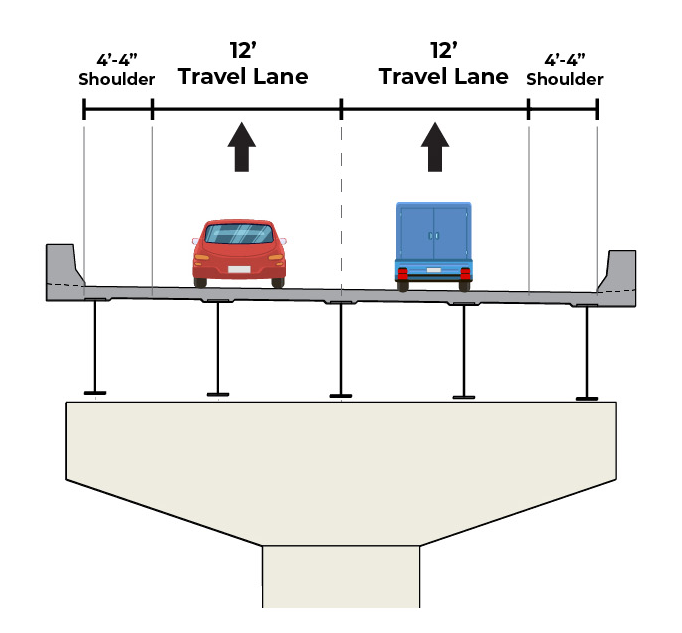 Existing Eastbound Typical Section (DRAFT)
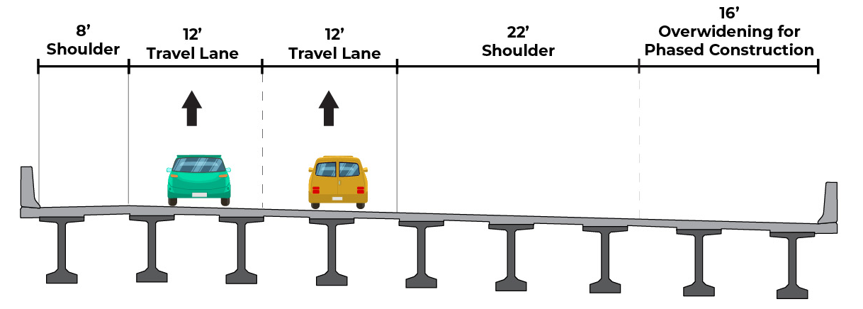
 Proposed Westbound Typical Section (DRAFT)
 Proposed Eastbound Typical Section (DRAFT)
Bridge Tolling
Funding
The estimated cost of construction of the I-80 Nescopeck Creek Bridges Project is between $40 million and $45 million.
PennDOT Pathways is a program to identify and implement alternative funding solutions for Pennsylvania's transportation system. As Pennsylvania's mobility needs have grown, the amount of funding required to support our transportation system has continued to increase. Much of our current funding comes from gas taxes and driver and vehicle fees. While this model worked well in the past, circumstances today have made it unsustainable. With PennDOT Pathways, we're looking for reliable, future-focused funding solutions that will meet our growing needs while serving our communities and all Pennsylvanians for generations to come.
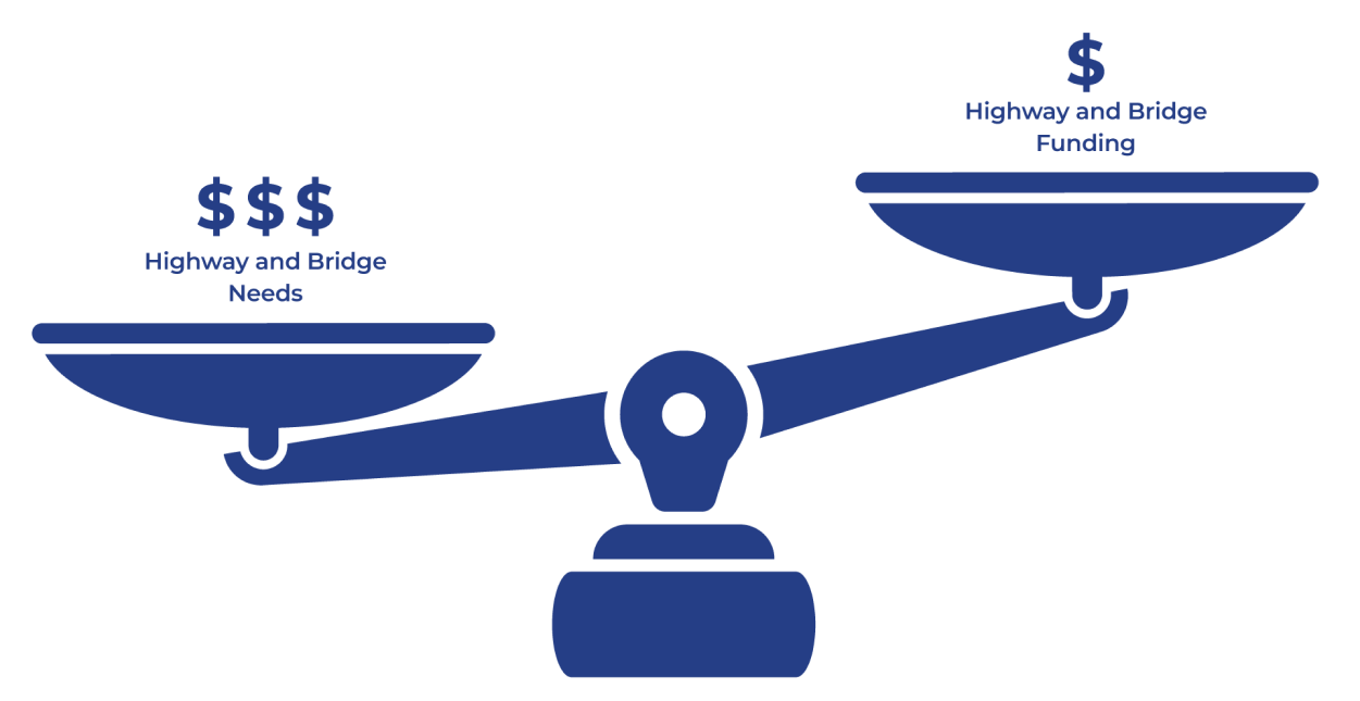
PennDOT currently faces an $8.1 billion gap in highway and bridge funding. This means we aren't generating enough funds to properly maintain, restore and expand our transportation system. PennDOT is taking action to find reliable sources of funding through the PennDOT Pathways program.
For more information about PennDOT Pathways, visit www.penndot.pa.gov/funding.
To support PennDOT Pathways, a Planning and Environmental Linkages (PEL) study was conducted to identify near- and long-term funding solutions and establish a methodology for their evaluation. One of the funding solutions identified was the implementation of bridge tolls on major bridge projects across the state. The I-80 Nescopeck Creek Bridges Project is one of nine projects being evaluated as a candidates for bridge tolling as a part of the PennDOT Pathways Major Bridge Public-Private Partnership (MBP3) Initiative. You can learn more about the program and initiative at the link above.
A bridge toll is a fee that drivers pay when using a specific bridge, often by using a service like E-ZPass. The funds received from this toll would go back to the I-80 Nescopeck Creek Bridges to pay for their construction, maintenance and operation.
Toll Implementation
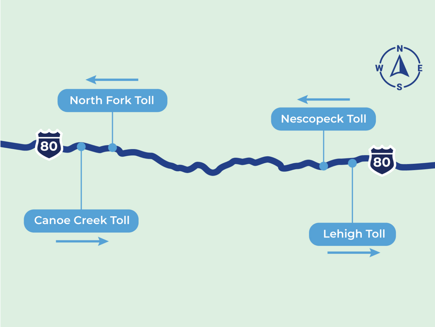
Based on feedback received from the public and at stakeholder workshops, and because of the close proximity of the two candidate bridges on the western end of I-80 and the two on the eastern end, PennDOT has decided to pursue one-way tolling on four bridge projects: Nescopeck, Lehigh River, Canoe Creek and North Fork. Traffic would be tolled westbound at Nescopeck and eastbound at Lehigh River, westbound at North Fork and eastbound at Canoe Creek. Tolls are expected to be $1-$2 for passenger cars using E-ZPass at each toll location. The one-way tolling will reduce overall diversions and reduce the need for additional tolling infrastructure to be built.
At the Nescopeck Creek Bridges Project, the proposed tolling facility would be constructed along the westbound direction of I-80 about a half-mile west of the new bridges and it would require the installation of a small driveway/parking area along the shoulder for maintenance and access. The tolling facility would not require drivers to stop to pay a toll when using the bridge but will record vehicles as they pass under the gantry sensor. A map of the toll gantry location is below.
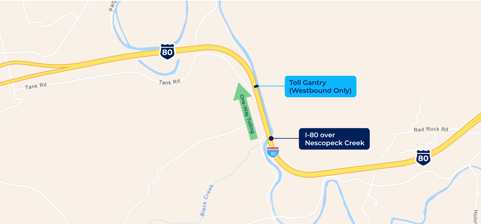
In addition, signs will be placed about 1 mile prior to the tolling facility to the east to inform drivers about the toll bridge, as well as at Exit 256 near Conyngham and its respective local roadway network, to notify drivers about the toll bridge.
Exact tolling amounts will be determined once design plans are finalized so the toll would generate enough revenue for the bridges' replacement and maintenance for a period of approximately 30 years. At the end of the 30-year term for the Public Private Partnership, the tolling facility would be removed.
Qualifying emergency vehicles would be permitted to use MBP3 bridges at no cost, following the Pennsylvania Turnpike Policy (PDF).
It is expected that toll collection on the bridge would begin between 2023 and 2025.
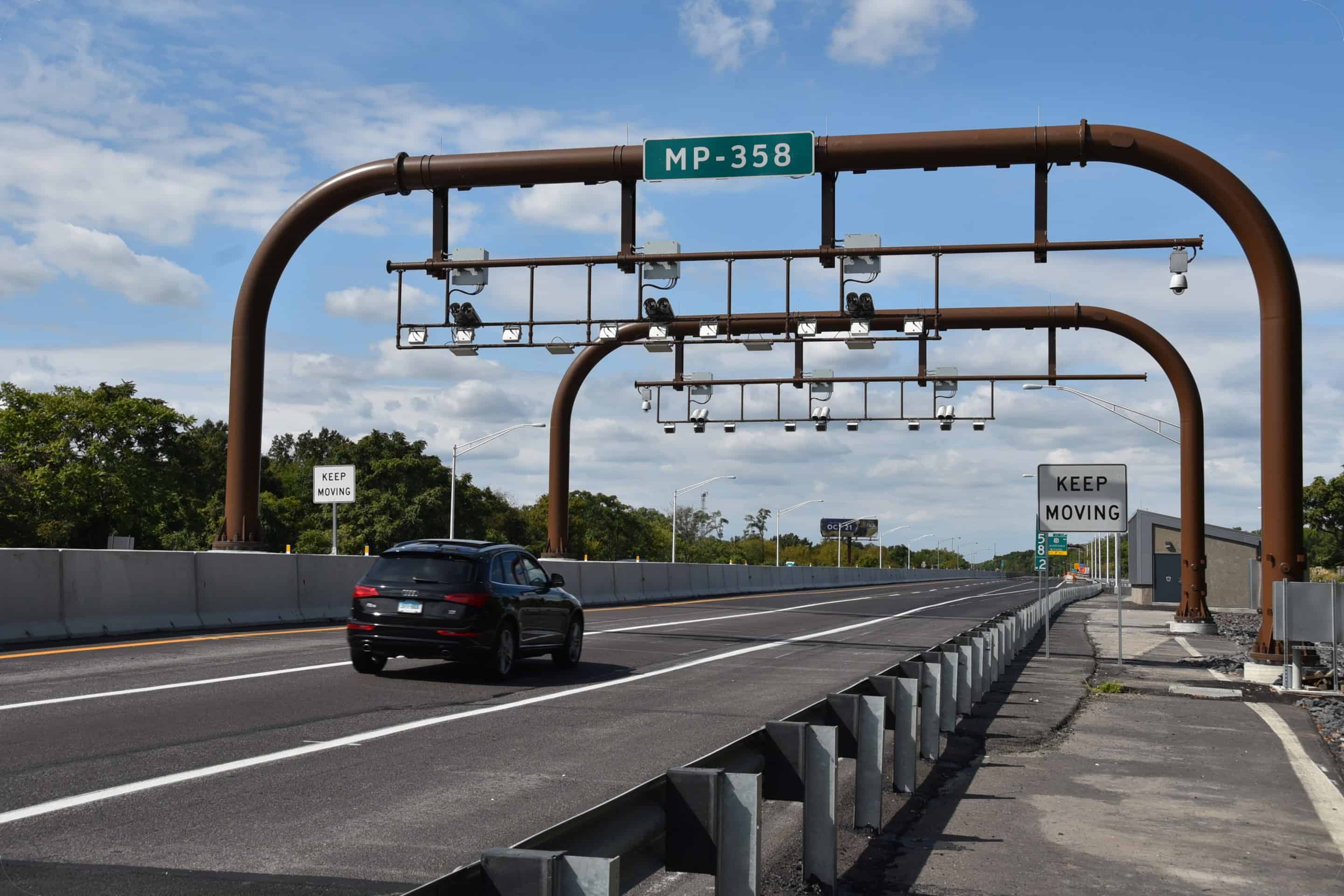 An example of an interstate toll gantry.
Environmental Studies & Mitigation
Environmental Assessment
An EA is a document that examines the significance of potential impacts to natural, social, economic and cultural resources from the alternative(s) under consideration. The EA for the I-80 Nescopeck Creek Bridges Project was prepared to address the requirements of NEPA, which requires federal agencies to assess the environmental effects of their proposed actions prior to making decisions.
The results of the EA's environmental analyses will determine whether an Environmental Impact Statement needs to be prepared, or whether a Finding of No Significant Impact can be issued.

Section 106 (Cultural Resources)
Section 106 of the National Historic Preservation Act is applicable to federal agencies and requires identification of, and assessment of effects on, historic properties and archaeological sites listed on, or eligible for listing on, the National Register of Historic Places (NRHP). Consultation with persons interested in the historic and archaeological properties/sites is integral to the Section 106 process and the public's involvement in the project. The Section 106 process includes identifying an area of potential effect (APE) for the project, and inviting property owners within that APE, as well as historical societies and others to participate in the Section 106 process as "Consulting Parties." Separate APEs are established for the archaeological investigations and for above-ground historical properties.
All proposed construction activities will take place within PennDOT's existing right of way, including existing roadbed and already-disturbed median and interchange areas. No further review under Section 106 is required.

Wetland and Waterways Impacts
Wetland and waterway impacts were studied as a part of the NEPA process. Overall, a few intermittent and perennial streams were observed along the Study Area; namely Nescopeck and Black Creeks as well as a few other unnamed tributaries to Nescopeck Creek. A few wetlands were also observed along the edge of Nescopeck Creek.
For the bridge replacement over Nescopeck Creek, the proposed construction activities will result in:
|
Permanent |
Temporary |
| Wetland Impacts |
0.052 acres |
0.12 acre |
| Stream Impacts |
444 linear feet |
732 linear feet |
Nescopeck Creek is listed as Approved Trout Waters by the Pennsylvania Fish and Boat Commission (PFBC). Therefore, in-stream work restrictions will be required between March 1 to June 15, unless a waiver is obtained.
Alongside the road embankments of I-80 and local roadways at Exit 256 where new advance tolling signs would be placed, a few freshwater wetlands were found but all would be avoided by the proposed project.
Overall, the proposed project would result in minor permanent impacts to Nescopeck Creek and its abutting freshwater wetlands during the construction of the new bridge structures, and all temporary impacts would be restored inkind after construction. The above in-stream work window restrictions would be followed by the contractor to avoid/minimize impacts to trout fishing. Finally, it is anticipated that minor stream and wetland mitigation requirements (offsite banking or onsite restoration) would be required by the U.S. Army Corps of Engineers and the Pennsylvania Department of Environmental Protection during final design and permitting.
Threatened and Endangered Plants and Animals
In studies of threatened and endangered plants and animals within the project area, potential habitat for the Indiana Bat was identified within the Study Area. To minimize potential impacts to the Indiana Bat, the U.S. Fish & Wildlife Service (USFWS) allows tree-cutting activities to only occur between November 15 and March 31.
Traffic Diversion
Traffic Diversion Analysis
Traffic diversion analysis is comprised of two distinct steps. The first is the development of the traffic model to predict how much traffic will divert off the interstate when a toll is imposed and what route that traffic will take. The second step is evaluating and analyzing the diversion routes identified to determine the impact of the diverted traffic on that route and to identify improvements to offset those impacts where appropriate.
A detailed traffic demand model was used to identify diversion routes. The existing statewide demand model that was employed is based on assumptions involving the transportation system, regional demographics and traveler characteristics. These assumptions were then combined using data from traffic counts (including the share of truck traffic), recorded travel speeds and origin and destination patterns, along with regional travel demand models. The model is then run under various parameters to predict the amount of traffic that will be diverted off the interstate and more importantly, where that traffic will go.
If a toll is placed on the I-80 Nescopeck Creek Bridges, an estimated 3 percent of daily traffic is expected to choose to divert off the interstate to avoid paying the toll, based on the results of the detailed traffic model. The model was also used to analyze what routes they would predominantly take. As mentioned above, based in part on feedback received from the public and stakeholders, PennDOT has decided to pursue one-way tolling and would only collect tolls on the westbound lanes at this bridge.
So where would the majority of the diverting traffic go? The primary diversion route identified for the Nescopeck Project is SR 93 for the eastern portion of the diversion and US Route 11 for the western portion of the diversion. This route is shown on the map below. You can click on the map to enlarge it.
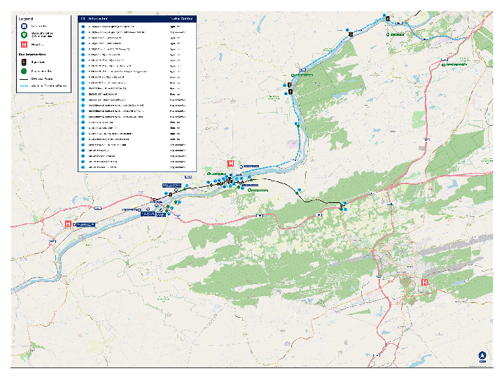 Click to view diversion map larger.
As you can see from the table below, the AM and PM Peak Hour traffic on the bridge will be reduced by approximately 60-70 vehicles per hour, and the primary diversion route will increase by approximately 40-50 vehicles per hour. The remaining diverted traffic will utilize a variety of other routes, but those routes will not be substantially impacted given the amount of traffic expected to use them.
Peak Hour Traffic Volume Table
| Route |
Time of Day |
Pre-Toll Traffic |
Post-Toll Traffic |
| Primary Diversion Route |
AM Peak Hour |
580 |
620 |
| Primary Diversion Route |
PM Peak Hour |
710 |
760 |
| I-80 Nescopeck Creek Bridges |
AM Peak Hour |
2,570 |
2,510 |
| I-80 Nescopeck Creek Bridges |
PM Peak Hour |
3,430 |
3,360 |
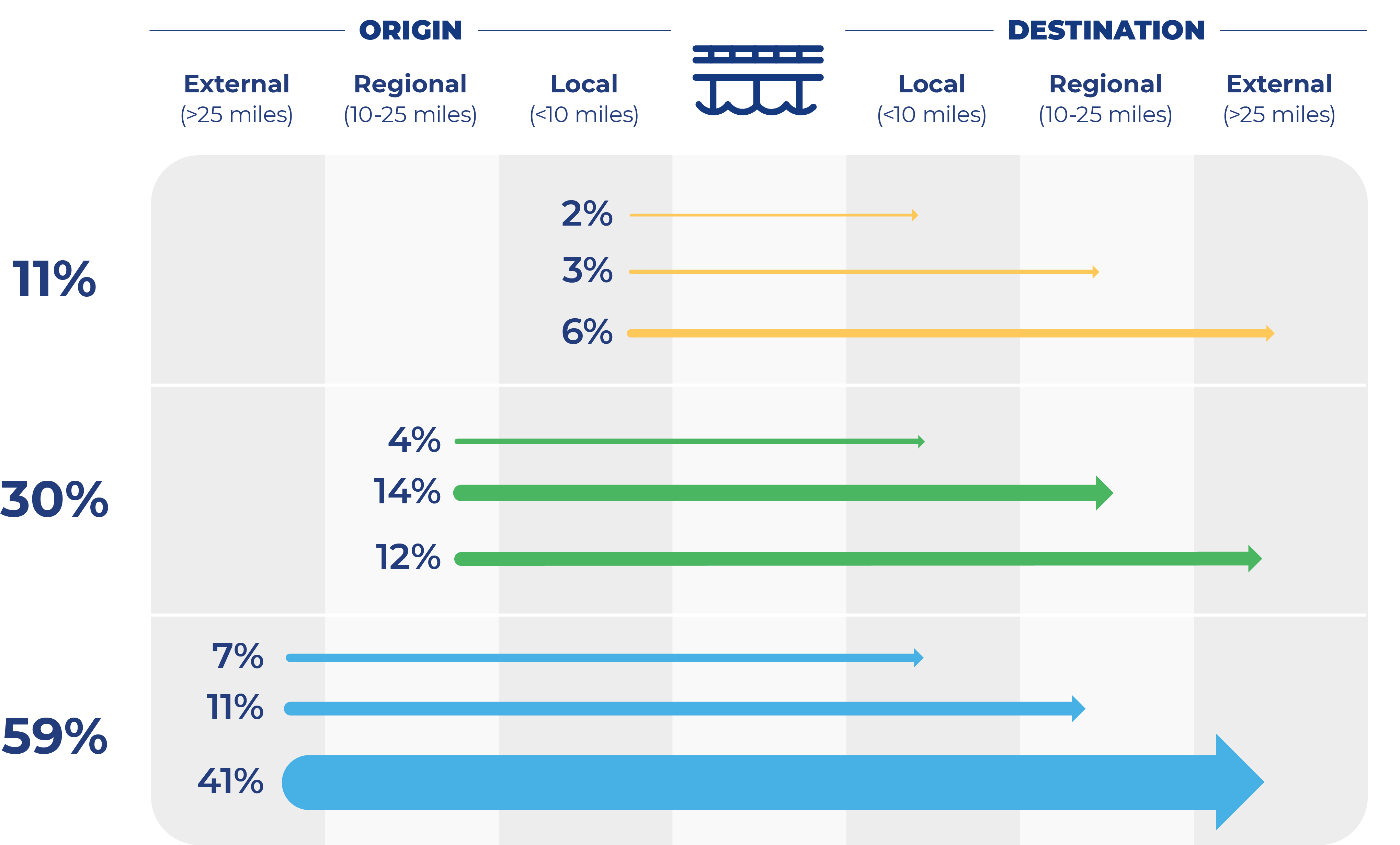
The origin-destination patterns are also taken into account in looking at diversion. The origin-destination criteria is divided into three categories: local (less than 10 miles), regional (10-25 miles) and external (more than 25 miles). As you can see in the graphic below, the majority of the traffic traveling over the bridges originates from external locations and is destined to external locations. Because these trips are typically long-distance trips, this type of traffic is more likely to stay on the interstate and not divert.
Traffic Demand Model
When people hear about vehicles diverting from the interstate to avoid a tolled bridge, they often envision what happens when there is a full traffic detour. To distinguish between a diversion and a detour in simple terms, diversions are a choice, detours are mandatory.
Detours are imposed because of construction or an incident on a roadway or bridge and those detours must be followed. In contrast to a detour, diversion from the interstate is a choice that drivers may make to avoid a toll and the diversion traffic is normally a small fraction of the number of vehicles compared to detours, when 100 percent of traffic leaves the interstate.
Traffic Diversion Methodology
Once it was determined how much traffic would divert and the primary route that would be utilized, a comprehensive evaluation of the impacts to the diversion route was undertaken. The graphic below highlights the key methodology for the evaluation of the diversion route.
Route Identification
Prioritize routes that add more than 100 vehicles per day
Traffic Projections
No toll vs. tolling scenario comparisons
Route Conditions
Intersections, traffic control, signage, & pavement conditions
Crash Data Summary
Identify crash patterns & crash rates
Capacity Analysis
Depict operational issues & capacity limitations
Roadway Review
Evaluation of lane widths and pavement structure
Alternative Transportation Modes
Transit, bus, bike lanes, etc.
Potential Mitigation Options
Evaluation of options to offset impacts to community
A workshop was conducted with key stakeholders (including elected officials, first responders, school districts, regional planners, etc.) in July 2021 to discuss the diversion route analysis, collect information on additional routes drivers might take and potential impacts from diverting traffic. This feedback was incorporated into the traffic diversion analysis and evaluated to identify potential ways PennDOT could mitigate impacts on the community caused by the toll diversion. At the workshop, some stakeholders did express concern in the diversion route that SR 339 is likely to be a more heavily used diversion route than US Route 11 for the western portion of the diversion route. The analysis and recommended improvements to offset effects are shared below.