U.S. 219 from Meyersdale to Old Salisbury Road
Somerset County, Pennsylvania, and Garrett County, Maryland.
Project Overview
PennDOT originally studied U.S. 219 improvements south of Somerset, Pennsylvania, during the 1990s. These studies identified a 5-mile section of U.S. 219 through Meyersdale, Pennsylvania, as the area's most immediate transportation problem. The Meyersdale Bypass project was constructed in 1998 as a four-lane, limited-access highway located to the west of existing U.S. 219 in Meyersdale Borough and Summit Township, Somerset County, Pennsylvania. The next project completed was an 11-mile, four-lane limited-access facility in 2018 from Somerset to Meyersdale. Then, in 2021, Maryland Department of Transportation State Highway Administration (MDOT SHA) completed the construction of an approximately 1.4-mile section from Interstate 68 (I-68) in Maryland to Old Salisbury Road, just south of the state line.
This current project addresses the remaining 7.5-mile portion of U.S. 219 from Meyersdale to Old Salisbury Road. PennDOT and MDOT SHA will build upon the 2016 Planning and Environmental Linkages (PEL) document that examined several alternatives within the established study area. All PEL alignments extended from the Meyersdale Bypass to I-68.
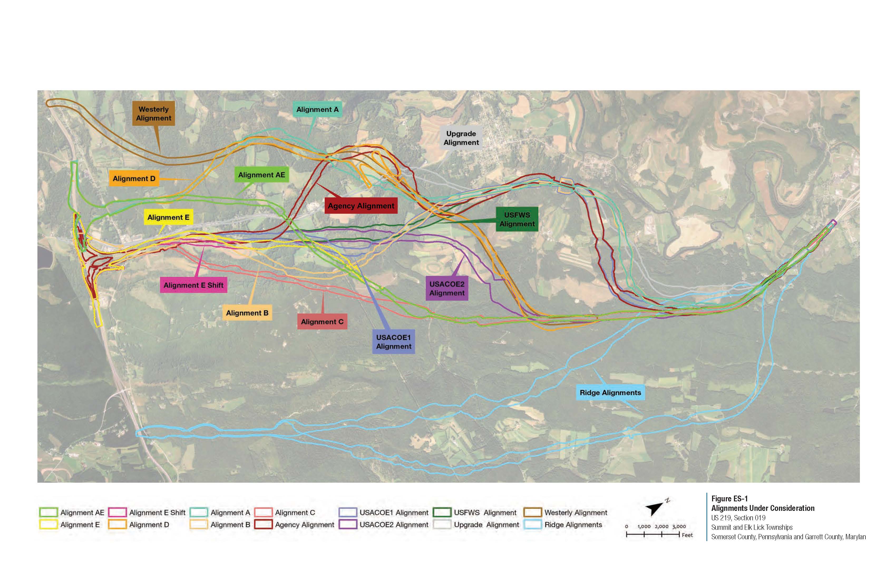 View a PDF of the U.S. 219 alignments previously under consideration map.
With the construction of the 1.4-mile section in the south, this project's southern terminus has been revised and is now the northern end of the newly constructed portion of U.S. 219, rather than I-68. Additionally, the PEL recommended that Alternatives E and E-shift be advanced and studied as part of the National Environmental Policy Act (NEPA) process.
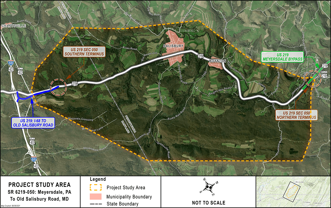 View a PDF of the project study area map.
When the team reinitiated studies in 2021, it was determined that in order to adequately consider a full range of alternatives in the EIS given the change in terminus, it would be necessary to evaluate more than just Alignments E and E-shift. It made logical sense to first look at Alignments AE and D as they were the two alignments that made it to Step 3 of the PEL Evaluation. Since both of these alignments ended at I-68 west of the current interchange and bisected the Casselman Farm Development, both alignments needed to be modified to tie into the current southern terminus. Alignment AE was eliminated from further consideration to be studied in the EIS because it essentially became the same alignment as Alignment E and E-shift once modified to tie into the new southern logical termini. Alignment D, however, due to its more northernly east-to-west crossing of the study area provided multiple opportunities to combine with the southern portion of previously dismissed PEL alignments to tie into the new southern terminus. The first of these combinations was with Agency Alternative which the team is now referring to as Alternative D/Agency (Alternative DA). This alignment uses the original D alignment to a point just west of where it crosses existing U.S. 219 and then it essentially follows the Agency alignment back to the new southern terminus. The second combination was with the original USFWS and USACOE2 alignments, which is being referred to as Alternative D/USFWS/USACOE (Alternative DU). This alternative again uses the northern portion of the D alignment but veers southeast of U.S. 219 in the same proximity as the original USFWS and USACOE2 alignments on its way to the new southern terminus. Finally, since a shift for Alignment E was evaluated in the vicinity of Old Salisbury Road near the southern terminus, it is appropriate to study the same shift for Alternatives DA and DU.
As mentioned above, the team has updated all secondary source data and conducted field views within the project area and determined that no significant changes have occurred in the study area that would invalidate the findings from the 2016 PEL. Due to these advancements in the study, the project study area was revised from what was used in the PEL Study to what is shown on the graphic below, which reflects the new logical southern terminus. None of the project area's natural, cultural and socio-economic environmental features have significantly changed since 2016 and would not significantly result in different impact quantities for the previously studied alternatives. Therefore, the team intends to carry Alternative DA, DA-Shift, DU, DU-Shift, E, E-Shift into the NEPA process. Additional studies will be completed on these alternatives to ultimately identify one preferred alternative. At this time, a preferred alternative has not been identified. The current alignments are shown on the map below.
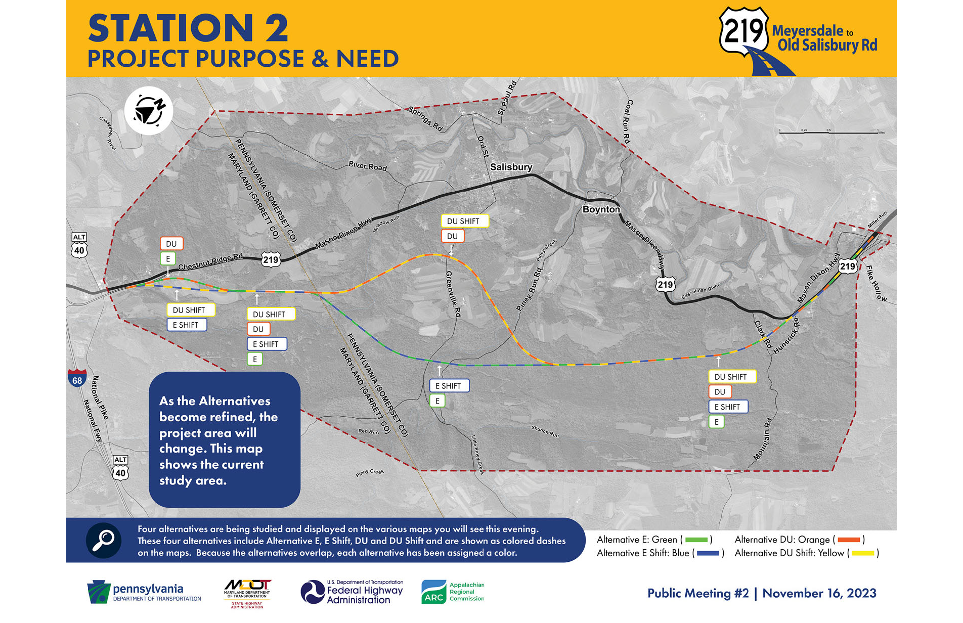
View a PDF of the U.S. 219 alignments currently under consideration map